Shelby County, Kentucky

Kufuma Wikipedia


Shelby County
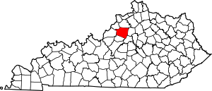
Map of Kentucky highlighting Shelby County
Location within the U.S. state of Kentucky
Map of the United States highlighting Kentucky
Kentucky's location within the U.S.
Coordinates: 38°13′N 85°11′W / 38.22°N 85.19°W / 38.22; -85.19
Country United States
StateTemplate:Country data Kentucky
Founded1792
Named forIsaac Shelby
SeatShelbyville
Largest cityShelbyville
Area
 • Total386 sq mi (1,000 km2)
 • Land380 sq mi (1,000 km2)
 • Water6.0 sq mi (16 km2)  1.6%
Population
 (2020)
 • Total48,065
 • Estimate 
(2021)
48,461 Increase
 • Density120/sq mi (48/km2)
Time zoneUTC−5 (Eastern)
 • Summer (DST)UTC−4 (EDT)
Congressional district4th
Websitewww.shelbycountykentucky.com

Shelby County, Kentucky ni malo/komboni panji nkhalwe (county) yakusangika mu boma/nthavwa (state) ya Kentucky mu charu cha United States of America ku Amelika.

Ukaboni[lemba | kulemba source]

Malo (counties) gha Kentucky
AdairAllenAndersonBallardBarrenBathBellBooneBourbonBoydBoyleBrackenBreathittBreckinridgeBullittButlerCaldwellCallowayCampbellCarlisleCarrollCarterCaseyChristianClarkClayClintonCrittendenCumberlandDaviessEdmonsonElliottEstillFayetteFlemingFloydFranklinFultonGallatinGarrardGrantGravesGraysonGreenGreenupHancockHardinHarlanHarrisonHartHendersonHenryHickmanHopkinsJacksonJeffersonJessamineJohnsonKentonKnottKnoxLaRueLaurelLawrenceLeeLeslieLetcherLewisLincolnLivingstonLoganLyonMcCrackenMcCrearyMcLeanMadisonMagoffinMarionMarshallMartinMasonMeadeMenifeeMercerMetcalfeMonroeMontgomeryMorganMuhlenbergNelsonNicholasOhioOldhamOwenOwsleyPendletonPerryPikePowellPulaskiRobertsonRockcastleRowanRussellScottShelbySimpsonSpencerTaylorToddTriggTrimbleUnionWarrenWashingtonWayneWebsterWhitleyWolfeWoodford