File:Topographic map of Gabon-en.svg

Page contents not supported in other languages.
Kufuma Wikipedia

Chinthu cha kwenekuko(SVG file, nominally 815 × 965 pixels, file size: 1.67 MB)

Chinthu ichi ntchaku Wikimedia Commons ndipo chingagwiliskikaso kunyake. Vakulongosola vake file description page vili pasi apa.

 
This W3C-unspecified vector image was created with Inkscape .

Mwakudumula

Malongosolelo
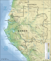
English: Topographic map of Gabon.
Suomi: Gabonin topograginen kartta.
Siku
Ukaboni Self-made in Inkscape (renamed from Image:Topographic map of Gabon.svg).
Boundaries, rivers and place names based on a public domain CIA map ([1] from the Perry-Castañeda Library Map Collection.
Topography based on public domain GLOBE data from NOAA (http://www.ngdc.noaa.gov/mgg/topo/gltiles.html).
Relief shading is an embedded bitmap, derived from the GLOBE data using Perl.
Bathymetry from NGDC ETOPO2.
Colors and overall look based on maps by User:Bamse.
Mlembi Mysid
Other versions

[kulemba]

Translate this file This SVG file contains embedded text that can be translated into your language, using any capable SVG editor, text editor or the SVG Translate tool. For more information see: About translating SVG files.

Chilolezo

I, the copyright holder of this work, hereby publish it under the following licenses:
GNU head Chilolezo ntchakupelekeka pakupanga copy, kutandazga panj kusintha na malango gha GNU Free Documentation License, Version 1.2 or any later version published by the Free Software Foundation; with no Invariant Sections, no Front-Cover Texts, and no Back-Cover Texts. A copy of the license is included in the section entitled GNU Free Documentation License.
w:en:Creative Commons
Viyambilo vya kuchita mwa kugaŵana
This file is licensed under the Creative Commons Attribution-Share Alike 4.0 International, 3.0 Unported, 2.5 Generic, 2.0 Generic and 1.0 Generic license.
Ndimwe ŵakuzomelezgeka:
  • kugaŵa – kuti mutandazge, kugaŵa na kusintha ntchito
  • kusazga – kusintha chito iyi
Pa malango ghakulondezga agha:
  • Viyambilo vya kuchita – Mukwenela kupeleka malumbo ghawemi, kupeleka linki yakutyonda ku chilolezo, kweneso yowoyaniso pala vinyake vyasintha. Mukwenela kuchita nthena mwakwenelela, kwambula kujikhalila khonde.
  • mwa kugaŵana – Pala mwasazga panji mwasintha chinthu, mukwenela kuchitandazga
na dango la same or compatible license nga ntchiphya.
You may select the license of your choice.
Annotations
InfoField
This image is annotated: View the annotations at Commons

Captions

Add a one-line explanation of what this file represents

Items portrayed in this file

depicts English

copyrighted English

inception English

16 Febuluwale 2008

Mbili ya chinthu

Dofyani pa siku/nyengo kuti muone umo vikaonekela pa nyengo iyo.

Siku/NyengoKachithuziVipimoMgwiliskiGanizo
sono11:02, 19 Epulelo 2008Kachithuzi kachoko nga mpha 11:02, 19 Epulelo 2008815 × 965 (1.67 MB)Bibi Saint-Pol{{Inkscape}} == {{int:filedesc}} == {{Information |Description= {{en|Topographic map of Gabon.}} {{fi|Gabonin topograginen kartta.}} |Source=Self-made in Inkscape.<br/>Boundaries, rivers and place names based on a public domain C

The following page uses this file:

Umo chinthu chagwiliskikila ntchito

Ma wiki ghanyake agho ghakugwiliska ichi: