
File:No-map.png
Saizi ya chakuona ichi: 276 × 598 pixels. Mu misani inyake: 110 × 240 pixels | 330 × 715 pixels.
Chinthu cha kwenekuko (330 × 715 pixels, file size: 37 KB, MIME type: image/png)
Mwakudumula
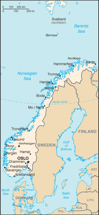
Map of Norway with countries south of Norway, Svalbard and Bjørnøya. See Image:Norway-map.png for a map without these areas.
Chilolezo
This image is in the public domain because it contains materials that originally came from the United States Central Intelligence Agency's World Factbook.
|
 |
Mbili ya chinthu
Dofyani pa siku/nyengo kuti muone umo vikaonekela pa nyengo iyo.
| Siku/Nyengo | Kachithuzi | Vipimo | Mgwiliski | Ganizo | |
|---|---|---|---|---|---|
| sono | 15:40, 3 Ogasiti 2006 | | 330 × 715 (37 KB) | Mathias-S | ==Licensing== {{PD-USGov-CIA-WF}} category:Maps of Norway |
Magwiliskilo ntchito
The following page uses this file:
Umo chinthu chagwiliskikila ntchito
Ma wiki ghanyake agho ghakugwiliska ichi:
- Magwiliskilo pa af.wikipedia.org
- Magwiliskilo pa ar.wikipedia.org
- Magwiliskilo pa be-tarask.wikipedia.org
- Magwiliskilo pa bg.wikipedia.org
- Magwiliskilo pa bn.wikipedia.org
- Magwiliskilo pa ca.wikipedia.org
- Magwiliskilo pa ckb.wikipedia.org
- Magwiliskilo pa cs.wikipedia.org
- Magwiliskilo pa da.wikipedia.org
- Magwiliskilo pa de.wikipedia.org
- Magwiliskilo pa el.wikipedia.org
- Magwiliskilo pa en.wikipedia.org
- Magwiliskilo pa fa.wikipedia.org
- Magwiliskilo pa fi.wikipedia.org
- Magwiliskilo pa fi.wikivoyage.org
- Magwiliskilo pa fr.wikipedia.org
- Magwiliskilo pa gag.wikipedia.org
- Magwiliskilo pa he.wikipedia.org
- Magwiliskilo pa ko.wikipedia.org
- Magwiliskilo pa lv.wikipedia.org
- Magwiliskilo pa mk.wikipedia.org
- Magwiliskilo pa nl.wikipedia.org
- Magwiliskilo pa nn.wikipedia.org
- Magwiliskilo pa pl.wikipedia.org
- Magwiliskilo pa pt.wikipedia.org
- Magwiliskilo pa rm.wikipedia.org
- Magwiliskilo pa ru.wikipedia.org
Wonani magwiliskilo ghanandi ghapa charu gha chinthu ichi.