
File:Map of Trans-African Highways.PNG
Saizi ya chakuona ichi: 600 × 600 pixels. Mu misani inyake: 240 × 240 pixels | 480 × 480 pixels | 832 × 832 pixels.
Chinthu cha kwenekuko (832 × 832 pixels, file size: 211 KB, MIME type: image/png)

|
This road map image could be re-created using vector graphics as an SVG file. This has several advantages; see Commons:Media for cleanup for more information. If an SVG form of this image is available, please upload it and afterwards replace this template with
{{vector version available|new image name}}.
It is recommended to name the SVG file “Map of Trans-African Highways.svg”—then the template Vector version available (or Vva) does not need the new image name parameter. |
Mwakudumula
| Malongosolelo |
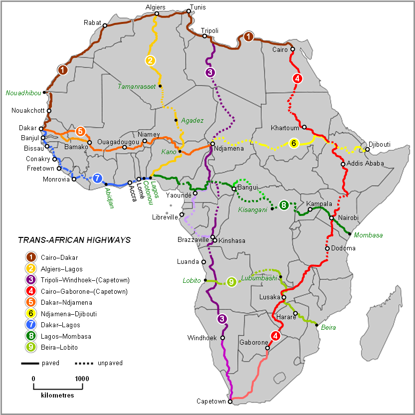
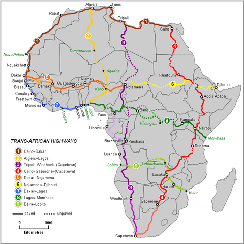
English: Map of Trans-African Highways based on data 2000 to 2003 |
| Siku | |
| Ukaboni | Word doc drawing based in Wikipedia blank Africa map |
| Mlembi | Rex Parry |
| Other versions |
|
Chilolezo
I, Rexparry sydney, the copyright holder of this work, hereby publishes it under the following licenses:

|
Chilolezo ntchakupelekeka pakupanga copy, kutandazga panj kusintha na malango gha GNU Free Documentation License, Version 1.2 or any later version published by the Free Software Foundation; with no Invariant Sections, no Front-Cover Texts, and no Back-Cover Texts. A copy of the license is included in the section entitled GNU Free Documentation License. |
| Chinthu ichi ntchakuzomelezgeka na Creative Commons Attribution-Share Alike 3.0 Unported license. | ||
| Attribution: I, Rexparry sydney | ||
na dango la same or compatible license nga ntchiphya. | ||
| This licensing tag was added to this file as part of the GFDL licensing update. |
This file is licensed under the Creative Commons Attribution-Share Alike 2.5 Generic, 2.0 Generic and 1.0 Generic license.
Attribution: I, Rexparry sydney
- Ndimwe ŵakuzomelezgeka:
- kugaŵa – kuti mutandazge, kugaŵa na kusintha ntchito
- kusazga – kusintha chito iyi
- Pa malango ghakulondezga agha:
- Viyambilo vya kuchita – Mukwenela kupeleka malumbo ghawemi, kupeleka linki yakutyonda ku chilolezo, kweneso yowoyaniso pala vinyake vyasintha. Mukwenela kuchita nthena mwakwenelela, kwambula kujikhalila khonde.
- mwa kugaŵana – Pala mwasazga panji mwasintha chinthu, mukwenela kuchitandazga
You may select the license of your choice.
| Annotations | This image is annotated: View the annotations at Commons |
Mbili ya chinthu
Dofyani pa siku/nyengo kuti muone umo vikaonekela pa nyengo iyo.
| Siku/Nyengo | Kachithuzi | Vipimo | Mgwiliski | Ganizo | |
|---|---|---|---|---|---|
| sono | 11:28, 19 Juni 2023 | | 832 × 832 (211 KB) | Abdelrhman 1990 | Map correction |
| 05:56, 6 Febuluwale 2022 |  | 832 × 832 (155 KB) | SounderBruce | Reverted to version as of 20:18, 8 November 2020 (UTC): Improper upscaling | |
| 00:45, 19 Janyuwale 2022 |  | 1,922 × 1,918 (1,016 KB) | Arrecife | 2022 update per Michelin Afrique & Google Earth | |
| 16:24, 14 Janyuwale 2022 |  | 615 × 614 (185 KB) | Arrecife | Reverted to version as of 05:53, 6 December 2019 (UTC) smaller size, but up to date | |
| 20:18, 8 Novembala 2020 |  | 832 × 832 (155 KB) | Leviavery | Reverted to version as of 09:25, 23 August 2019 (UTC) Much higher quality image | |
| 05:53, 6 Disembala 2019 |  | 615 × 614 (185 KB) | Arrecife | Updating of all roads, from Michelin Africa plus Google Earth | |
| 09:25, 23 Ogasiti 2019 |  | 832 × 832 (155 KB) | NordNordWest | adding South Sudan | |
| 00:02, 9 Okutobala 2014 |  | 832 × 832 (202 KB) | Bobrayner | Slight corrections/updates to map, ie. Nouakchott-Nouadhibou road was completely surfaced a few years ago Morocco-Algeria border is closed; &c. | |
| 07:12, 18 Julayi 2007 |  | 832 × 832 (175 KB) | Rexparry sydney~commonswiki | {{Information |Description=Map of Trans-African Highways based on data 2000 to 2003 |Source=Word doc drawing based in Wikipedia blank Africa map |Date=17 July 2007 |Author=Rex Parry |Permission=Yes |other_versions= }} |
Magwiliskilo ntchito
The following page uses this file:
Umo chinthu chagwiliskikila ntchito
Ma wiki ghanyake agho ghakugwiliska ichi:
- Magwiliskilo pa af.wikipedia.org
- Magwiliskilo pa ar.wikipedia.org
- Magwiliskilo pa arz.wikipedia.org
- Magwiliskilo pa bs.wikipedia.org
- Magwiliskilo pa de.wikipedia.org
- Magwiliskilo pa en.wikipedia.org
- Magwiliskilo pa es.wikipedia.org
- Magwiliskilo pa fa.wikipedia.org
- Magwiliskilo pa fr.wikipedia.org
- Magwiliskilo pa he.wikipedia.org
- Magwiliskilo pa hu.wikipedia.org
- Magwiliskilo pa hy.wikipedia.org
- Magwiliskilo pa id.wikipedia.org
- Magwiliskilo pa it.wikipedia.org
- Magwiliskilo pa it.wikivoyage.org
- Magwiliskilo pa ja.wikipedia.org
- Magwiliskilo pa kk.wikipedia.org
- Magwiliskilo pa nl.wikipedia.org
- Magwiliskilo pa no.wikipedia.org
- Magwiliskilo pa pl.wikipedia.org
- Magwiliskilo pa pt.wikipedia.org
Wonani magwiliskilo ghanandi ghapa charu gha chinthu ichi.