
File:Colorado geographic map-en.svg

Size of this PNG preview of this SVG file: 703 × 599 pixels. Mu misani inyake: 282 × 240 pixels | 563 × 480 pixels | 901 × 768 pixels | 1,201 × 1,024 pixels | 2,403 × 2,048 pixels | 2,581 × 2,200 pixels.
Chinthu cha kwenekuko (SVG file, nominally 2,581 × 2,200 pixels, file size: 7.2 MB)
Mwakudumula
| Malongosolelo |
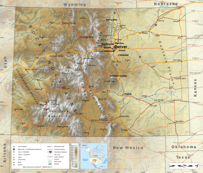
English: Geographic map of Colorado in English. Geographic limits of the map:
|
||
| Siku | |||
| Ukaboni |
Chinthu chane
|
||
| Mlembi | Ikonact | ||
| Chilolezo (Kugwiliskaso ntchito ichi) |
Any use of this map is subject of the license(s) stated below with the condition that you credit (Wikimedia Commons user: Ikonact) as the author . A message with a reply address would also be greatly appreciated. | ||
| SVG genesis |
|
Chilolezo
I, the copyright holder of this work, hereby publish it under the following license:
This file is licensed under the Creative Commons Attribution-Share Alike 4.0 International license.
- Ndimwe ŵakuzomelezgeka:
- kugaŵa – kuti mutandazge, kugaŵa na kusintha ntchito
- kusazga – kusintha chito iyi
- Pa malango ghakulondezga agha:
- Viyambilo vya kuchita – Mukwenela kupeleka malumbo ghawemi, kupeleka linki yakutyonda ku chilolezo, kweneso yowoyaniso pala vinyake vyasintha. Mukwenela kuchita nthena mwakwenelela, kwambula kujikhalila khonde.
- mwa kugaŵana – Pala mwasazga panji mwasintha chinthu, mukwenela kuchitandazga
Mbili ya chinthu
Dofyani pa siku/nyengo kuti muone umo vikaonekela pa nyengo iyo.
| Siku/Nyengo | Kachithuzi | Vipimo | Mgwiliski | Ganizo | |
|---|---|---|---|---|---|
| sono | 19:49, 19 Juni 2020 | | 2,581 × 2,200 (7.2 MB) | Ikonact | eastern plains |
| 11:30, 23 Okutobala 2019 |  | 2,581 × 2,200 (6.7 MB) | Ikonact | svg valid, fall back font | |
| 21:21, 22 Okutobala 2019 |  | 2,581 × 2,200 (7.2 MB) | Ikonact | ++ | |
| 20:53, 22 Okutobala 2019 |  | 2,581 × 2,200 (7.2 MB) | Ikonact | mountain names | |
| 22:03, 21 Okutobala 2019 |  | 2,581 × 2,200 (7.19 MB) | Ikonact | + names | |
| 21:41, 21 Okutobala 2019 |  | 2,581 × 2,200 (7.19 MB) | Ikonact | == {{int:filedesc}} == {{Information |description={{en|1=Geographic map of Colorado in English. Geographic limits of the map:}} *N: 41.20° N *S: 38.80° N *W: 109.40° W *E: 101.60° W Albers equal area projection; WGS 84 datum |date=2019-10-21 |source={{own}} *Sources of data:<br/> **Topography: ETOPO1 (public domain);<br/> **Public domain data provided by the National Atlas of the United States of America;<br/> *Tool:<br/> **The map is created with Octave scripts developed by... |
Magwiliskilo ntchito
The following page uses this file:
Umo chinthu chagwiliskikila ntchito
Ma wiki ghanyake agho ghakugwiliska ichi:
- Magwiliskilo pa ang.wikipedia.org
- Magwiliskilo pa be.wikipedia.org
- Magwiliskilo pa bg.wikipedia.org
- Magwiliskilo pa ca.wikipedia.org
- Magwiliskilo pa en.wikipedia.org
- Magwiliskilo pa es.wikipedia.org
- Magwiliskilo pa fr.wikipedia.org
- Magwiliskilo pa ga.wikipedia.org
- Magwiliskilo pa gl.wikipedia.org
- Magwiliskilo pa hu.wikipedia.org
- Magwiliskilo pa hy.wikipedia.org
- Magwiliskilo pa id.wikipedia.org
- Magwiliskilo pa it.wikipedia.org
- Magwiliskilo pa lo.wikipedia.org
- Magwiliskilo pa mhr.wikipedia.org
- Magwiliskilo pa os.wikipedia.org
- Magwiliskilo pa tg.wikipedia.org
- Magwiliskilo pa tt.wikipedia.org
- Magwiliskilo pa www.wikidata.org