
File:1860 Colorado Territory map.svg

Size of this PNG preview of this SVG file: 448 × 303 pixels. Mu misani inyake: 320 × 216 pixels | 640 × 433 pixels | 1,024 × 693 pixels | 1,280 × 866 pixels | 2,560 × 1,731 pixels.
Chinthu cha kwenekuko (SVG file, nominally 448 × 303 pixels, file size: 107 KB)
Mwakudumula
| Malongosolelo |
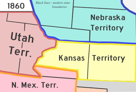
English: A map of Colorado Territory in 1860. Based off File:Wpdms kansas nebraska utah territories 1860 idx.png |
| Siku | |
| Ukaboni | Chinthu chane |
| Mlembi | Rcsprinter123 |
| Other versions |
 |
| SVG genesis | This vector image was created with Inkscape. |
Chilolezo
| I, the copyright holder of this work, release this work into the public domain. This applies worldwide. In some countries this may not be legally possible; if so: I grant anyone the right to use this work for any purpose, without any conditions, unless such conditions are required by law. |
Mbili ya chinthu
Dofyani pa siku/nyengo kuti muone umo vikaonekela pa nyengo iyo.
| Siku/Nyengo | Kachithuzi | Vipimo | Mgwiliski | Ganizo | |
|---|---|---|---|---|---|
| sono | 10:10, 2 Juni 2023 | | 448 × 303 (107 KB) | Rcsprinter123 | == {{int:filedesc}} == {{Information |Description = {{en|1=A map of Colorado Territory in 1860. Based off File:Wpdms kansas nebraska utah territories 1860 idx.png }} |Source = {{own}} |Author = {{u|Rcsprinter123}} |other fields={{Igen|Inkscape|+}} |Date = 2013-08-24 |Permission = |other_versions = 140px }} == {{int:license-header}} == {{PD-self}} [[Category:Maps of f... |
Magwiliskilo ntchito
The following page uses this file:
Umo chinthu chagwiliskikila ntchito
Ma wiki ghanyake agho ghakugwiliska ichi:
- Magwiliskilo pa ca.wikipedia.org
- Magwiliskilo pa en.wikipedia.org
- Magwiliskilo pa es.wikipedia.org
- Magwiliskilo pa fi.wikipedia.org
- Magwiliskilo pa he.wikipedia.org
- Magwiliskilo pa ig.wikipedia.org
- Magwiliskilo pa it.wikipedia.org
- Magwiliskilo pa ko.wikipedia.org
- Magwiliskilo pa pt.wikipedia.org
- Magwiliskilo pa ru.wikipedia.org
- Magwiliskilo pa vi.wikipedia.org
- Magwiliskilo pa zh.wikipedia.org