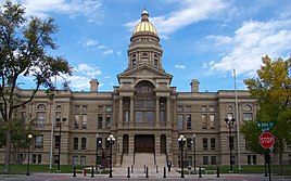
Cheyenne, Wyoming
Kaonekelo
Cheyenne, Wyoming | |||
|---|---|---|---|
State capital and city | |||
Left to right from top: Downtown Cheyenne, Cheyenne Depot Museum, Union Pacific Big Boy 4004 and the Wyoming State Capitol | |||
| |||
| Nickname: "Magic City of the Plains" (historic) | |||
 Location in Laramie County in Wyoming | |||
| Lua error in Module:Location_map at line 522: Unable to find the specified location map definition: "Module:Location map/data/Wyoming" does not exist. | |||
| Coordinates: 41°8′24″N 104°49′13″W / 41.14000°N 104.82028°W | |||
| Country | United States | ||
| State | Wyoming | ||
| County | Laramie | ||
| Founded | 1867 | ||
| Named for | Cheyenne people | ||
| Government | |||
| • Mayor | Patrick Collins[1] | ||
| Area | |||
| • City | 32.37 sq mi (83.84 km2) | ||
| • Land | 32.26 sq mi (83.55 km2) | ||
| • Water | 0.11 sq mi (0.29 km2) 0.45% | ||
| Elevation | 6,062 ft (1,848 m) | ||
| Population | |||
| • City | 65,132 | ||
| • Density | 1,991.23/sq mi (768.82/km2) | ||
| Time zone | UTC−7 (Mountain) | ||
| • Summer (DST) | UTC−6 (Mountain) | ||
| ZIP Code | 82001–82003, 82006–82010 | ||
| Area code | 307 | ||
| FIPS code | 56-13900[4] | ||
| GNIS feature ID | 1609077[5] | ||
| Highways | |||
| Website | www | ||
Cheyenne ni msumba ukulu wa boma mu state ya Wyoming chalo cha United States.
Ukaboni
[lemba | kulemba source]- ↑ Mayor's Office, Cheyenne.
- ↑ "2019 U.S. Gazetteer Files". United States Census Bureau. Retrieved August 7, 2020.
- ↑ Cite error: Invalid
<ref>tag; no text was provided for refs namedFactFinder - ↑ "American FactFinder". United States Census Bureau. Archived from the original on February 12, 2020. Retrieved January 31, 2008.
- ↑ "US Board on Geographic Names". United States Geological Survey. October 25, 2007. Archived from the original on February 4, 2012. Retrieved January 31, 2008.


