
File:Zambezi river basin-fr.svg

Size of this PNG preview of this SVG file: 800 × 511 pixels. Mu misani inyake: 320 × 204 pixels | 640 × 409 pixels | 1,024 × 654 pixels | 1,280 × 818 pixels | 2,560 × 1,636 pixels | 2,931 × 1,873 pixels.
Chinthu cha kwenekuko (SVG file, nominally 2,931 × 1,873 pixels, file size: 2.12 MB)
Mwakudumula
| Malongosolelo | |||
| Siku | |||
| Ukaboni |
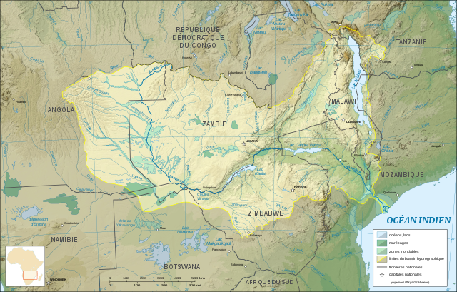
Chinthu chane (Original text: Own work ; Topographic background map : NASA Shuttle Radar Topography Mission (SRTM30 v.2) (public domain) edited with MicroDEM and dlgv32 Pro / Global Mapper ; UTM projection ; WGS84 datum ; References for the additional data : Demis World Map data (see the approval e-mail and the Demis forum) and UNESCO map ; Locator map : File:Africa map blank.svg (modified) created by myself.) |
||
| Mlembi | Eric Gaba (Sting - fr:Sting) | ||
| Chilolezo (Kugwiliskaso ntchito ichi) |
|
||
| Other versions |
Derivative works of this file: |
||
| SVG genesis |

Chilolezo
I, Sting, the copyright holder of this work, hereby publishes it under the following licenses:

|
Chilolezo ntchakupelekeka pakupanga copy, kutandazga panj kusintha na malango gha GNU Free Documentation License, Version 1.2 or any later version published by the Free Software Foundation; with no Invariant Sections, no Front-Cover Texts, and no Back-Cover Texts. A copy of the license is included in the section entitled GNU Free Documentation License. |
| Chinthu ichi ntchakuzomelezgeka na Creative Commons Attribution-Share Alike 3.0 Unported license. | ||
| Attribution: I, Sting | ||
na dango la same or compatible license nga ntchiphya. | ||
| This licensing tag was added to this file as part of the GFDL licensing update. |
This file is licensed under the Creative Commons Attribution-Share Alike 2.5 Generic, 2.0 Generic and 1.0 Generic license.
Attribution: I, Sting
- Ndimwe ŵakuzomelezgeka:
- kugaŵa – kuti mutandazge, kugaŵa na kusintha ntchito
- kusazga – kusintha chito iyi
- Pa malango ghakulondezga agha:
- Viyambilo vya kuchita – Mukwenela kupeleka malumbo ghawemi, kupeleka linki yakutyonda ku chilolezo, kweneso yowoyaniso pala vinyake vyasintha. Mukwenela kuchita nthena mwakwenelela, kwambula kujikhalila khonde.
- mwa kugaŵana – Pala mwasazga panji mwasintha chinthu, mukwenela kuchitandazga
You may select the license of your choice.
Mbili ya chinthu
Dofyani pa siku/nyengo kuti muone umo vikaonekela pa nyengo iyo.
| Siku/Nyengo | Kachithuzi | Vipimo | Mgwiliski | Ganizo | |
|---|---|---|---|---|---|
| sono | 19:09, 19 Janyuwale 2008 | | 2,931 × 1,873 (2.12 MB) | Sting | Trying other solution (part 2) |
| 19:03, 19 Janyuwale 2008 |  | 2,440 × 1,560 (832 KB) | Sting | Trying other solution (part 1) | |
| 13:04, 31 Julayi 2007 |  | 2,931 × 1,873 (2.12 MB) | Sting | Again... | |
| 12:53, 31 Julayi 2007 |  | 2,931 × 1,873 (2.3 MB) | Sting | Again | |
| 12:46, 31 Julayi 2007 |  | 2,931 × 1,873 (2.31 MB) | Sting | Again | |
| 12:35, 31 Julayi 2007 |  | 2,931 × 1,873 (2.31 MB) | Sting | Again | |
| 12:16, 31 Julayi 2007 |  | 2,931 × 1,873 (2.31 MB) | Sting | Display problem with the raster background map | |
| 02:30, 31 Julayi 2007 |  | 2,931 × 1,873 (2.28 MB) | Sting | {{Information |Description=Map in French of the Zambezi river hydrographic basin, Africa |Source=Own work ;<br/>Topographic background map : [http://www2.jpl.nasa.gov/srtm NASA Shuttle Radar Topography Mission] (SRTM30 v.2) (public domain) edited with [ht |
Magwiliskilo ntchito
Palije majani agho ghogwiliska chinthu ichi.
Umo chinthu chagwiliskikila ntchito
Ma wiki ghanyake agho ghakugwiliska ichi:
- Magwiliskilo pa ar.wikipedia.org
- Magwiliskilo pa es.wikipedia.org
- Magwiliskilo pa eu.wikipedia.org
- Magwiliskilo pa fr.wikipedia.org
- Magwiliskilo pa gl.wikipedia.org
- Magwiliskilo pa ky.wikipedia.org
- Magwiliskilo pa ln.wikipedia.org
- Magwiliskilo pa uk.wikipedia.org