
File:RegioniIrredenteItalia.jpg
Saizi ya chakuona ichi: 460 × 600 pixels. Mu misani inyake: 184 × 240 pixels | 632 × 824 pixels.
Chinthu cha kwenekuko (632 × 824 pixels, file size: 247 KB, MIME type: image/jpeg)
Mwakudumula
| Malongosolelo |
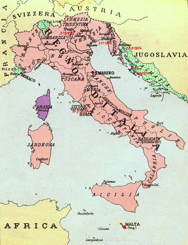
Map of Kingdom of Italy (1919) showing the areas claimed by Irredentism: in red Malta, in purple Corsica, in yellow with green points Dalmatia, Ticino and Nizzardo. I have used as a basic map an old map from an Italian geography and history school book of 1935 "Scuole Medie Inferiori", and I have written and painted on it. Cropped caption: L’Italia dopo la Guerra 1915-1918 |
| Siku | |
| Ukaboni | Chinthu chane |
| Mlembi | Brunodambrosio |
| Other versions | File:Nesvobodni rajoni Italija.png |
Chilolezo
| I, the copyright holder of this work, release this work into the public domain. This applies worldwide. In some countries this may not be legally possible; if so: I grant anyone the right to use this work for any purpose, without any conditions, unless such conditions are required by law. |
Mbili ya chinthu
Dofyani pa siku/nyengo kuti muone umo vikaonekela pa nyengo iyo.
| Siku/Nyengo | Kachithuzi | Vipimo | Mgwiliski | Ganizo | |
|---|---|---|---|---|---|
| sono | 21:34, 17 Ogasiti 2023 | | 632 × 824 (247 KB) | 0m9Ep | Color |
| 10:14, 23 Disembala 2017 |  | 632 × 824 (262 KB) | Julieta39 | Blù delle mare | |
| 22:58, 7 Juni 2012 |  | 632 × 824 (119 KB) | Ras67 | losslessly cropped with Jpegcrop | |
| 22:01, 16 Epulelo 2008 |  | 669 × 903 (144 KB) | Brunodambrosio | {{Information |Description=Map of Kingdom of Italy (1919) showing the areas claimed by Irredentism:in red Malta, in purple Corsica, in yellow with green points Dalmatia, Ticino and Nizzardo. I have used as a basic map an old map from an italian geography |
Magwiliskilo ntchito
The following page uses this file:
Umo chinthu chagwiliskikila ntchito
Ma wiki ghanyake agho ghakugwiliska ichi:
- Magwiliskilo pa als.wikipedia.org
- Magwiliskilo pa ar.wikipedia.org
- Magwiliskilo pa ast.wikipedia.org
- Magwiliskilo pa az.wikipedia.org
- Magwiliskilo pa be-tarask.wikipedia.org
- Magwiliskilo pa be.wikipedia.org
- Magwiliskilo pa ca.wikipedia.org
- Magwiliskilo pa cs.wikipedia.org
- Magwiliskilo pa de.wikipedia.org
- Magwiliskilo pa de.wiktionary.org
- Magwiliskilo pa en.wikipedia.org
- Foreign relations of Italy
- Irredentism
- Italian irredentism
- History of the Kingdom of Italy (1861–1946)
- List of irredentist claims or disputes
- Italian fascism
- Kingdom of Italy
- History of Corsica
- Italian irredentism in Corsica
- Benito Mussolini
- Italian irredentism in Malta
- Italian irredentism in Switzerland
- User:Brothernight/sandbox
- Magwiliskilo pa eo.wikipedia.org
- Magwiliskilo pa es.wikipedia.org
- Magwiliskilo pa fa.wikipedia.org
- Magwiliskilo pa fr.wikipedia.org
- Magwiliskilo pa he.wikipedia.org
- Magwiliskilo pa hr.wikipedia.org
- Magwiliskilo pa hu.wikipedia.org
- Magwiliskilo pa hy.wikipedia.org
- Magwiliskilo pa id.wikipedia.org
Wonani magwiliskilo ghanandi ghapa charu gha chinthu ichi.