
File:Map of traditional provinces of Libye-en.svg

Size of this PNG preview of this SVG file: 625 × 599 pixels. Mu misani inyake: 250 × 240 pixels | 501 × 480 pixels | 801 × 768 pixels | 1,068 × 1,024 pixels | 2,136 × 2,048 pixels | 969 × 929 pixels.
Chinthu cha kwenekuko (SVG file, nominally 969 × 929 pixels, file size: 106 KB)
| Malongosolelo |
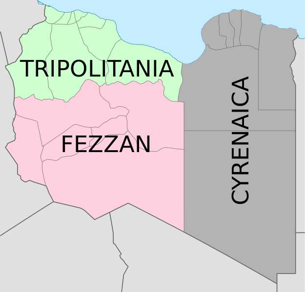
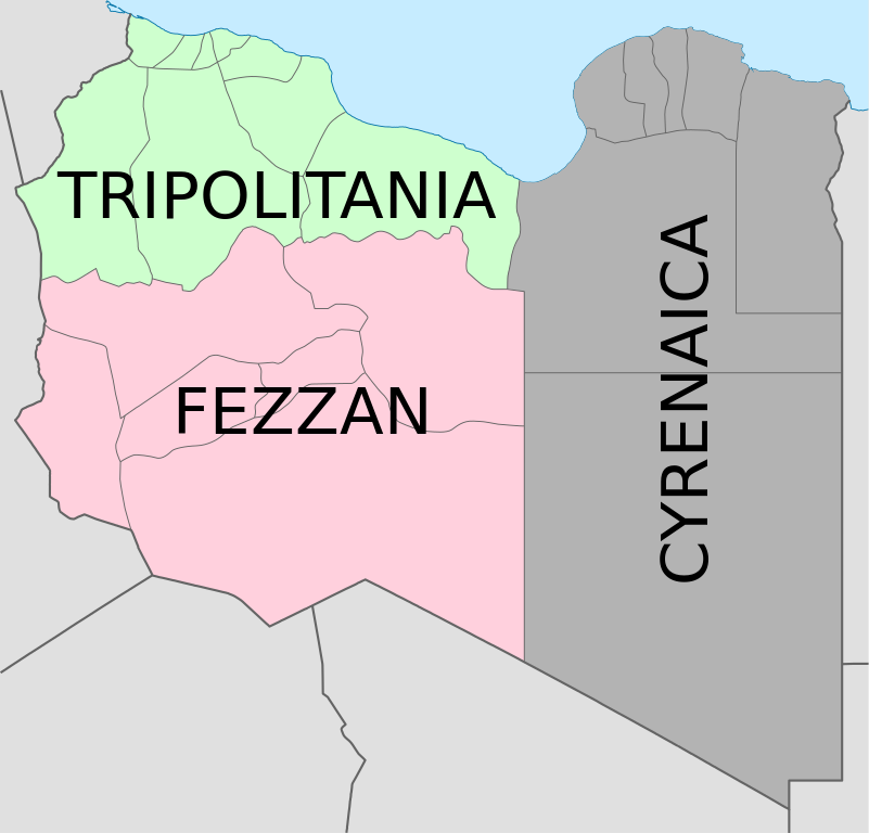
Deutsch: Historische provinzen (Governorates) Libyens English: Map of the three Governorates of Libya based on the borders of today's governorates. After independence in 1951, until 1963, Libya was divided into three governorates (muhafazat): Cyrenaica, Tripolitania, and Fezzan. The eastern border between Tripolitania and Fezzan was before 1969 slightly different: the northern part of Al Jufrah District in today's Fezzan belonged to Tripolitania, see here File:Ottoman Provinces Of Present day Libyapng.png. Español: Mapa de las tres governorates de Libia: Tripolitania, Fezzan, y Cirenaica. Français : Carte en anglais des trois provinces historiques (gouvernorats) de la Libye contemporaine. |
| Siku | (UTC) |
| Ukaboni | |
| Mlembi |
|
| Other versions |
|


| This is a retouched picture, which means that it has been digitally altered from its original version. Modifications: translation in english. The original can be viewed here: Map of traditionnal provinces of Libye fr.svg:
|
I, the copyright holder of this work, hereby publish it under the following licenses:
This file is licensed under the Creative Commons Attribution 3.0 Unported license.
- Ndimwe ŵakuzomelezgeka:
- kugaŵa – kuti mutandazge, kugaŵa na kusintha ntchito
- kusazga – kusintha chito iyi
- Pa malango ghakulondezga agha:
- Viyambilo vya kuchita – Mukwenela kupeleka malumbo ghawemi, kupeleka linki yakutyonda ku chilolezo, kweneso yowoyaniso pala vinyake vyasintha. Mukwenela kuchita nthena mwakwenelela, kwambula kujikhalila khonde.

|
Chilolezo ntchakupelekeka pakupanga copy, kutandazga panj kusintha na malango gha GNU Free Documentation License, Version 1.2 or any later version published by the Free Software Foundation; with no Invariant Sections, no Front-Cover Texts, and no Back-Cover Texts. A copy of the license is included in the section entitled GNU Free Documentation License. |
You may select the license of your choice.
Original upload log
This image is a derivative work of the following images:
- File:Map_of_traditionnal_provinces_of_Libye_fr.svg licensed with Cc-by-3.0, GFDL
- 2011-02-25T14:34:29Z Пакко 969x929 (120204 Bytes) upg
- 2011-02-25T13:46:48Z Xfigpower 970x931 (162661 Bytes) {{Information |Description={{fr|les trois provinces mappées sur la arte actuelle de la LibyeLes couleurs sont celles symbolisées par le drapeau}} |Source=*[[:File:Libya_location_map.svg|]] |Date=2011-02-25 13:29 (UTC) |Auth
Uploaded with derivativeFX
Mbili ya chinthu
Dofyani pa siku/nyengo kuti muone umo vikaonekela pa nyengo iyo.
| Siku/Nyengo | Kachithuzi | Vipimo | Mgwiliski | Ganizo | |
|---|---|---|---|---|---|
| sono | 08:36, 24 Ogasiti 2021 | | 969 × 929 (106 KB) | أحمد الغرباوي | File uploaded using svgtranslate tool (https://svgtranslate.toolforge.org/). Added translation for ar. |
| 15:44, 6 Disembala 2020 |  | 969 × 929 (104 KB) | ידידיה צ' צבאן | File uploaded using svgtranslate tool (https://svgtranslate.toolforge.org/). Added translation for he. | |
| 03:46, 12 Okutobala 2011 |  | 969 × 929 (104 KB) | Spesh531 | updated to current internal boundaries | |
| 12:50, 30 Ogasiti 2011 |  | 969 × 929 (147 KB) | Orange Tuesday | see http://www.crwflags.com/fotw/flags/ly_1951.html for source on traditional colours | |
| 01:40, 30 Ogasiti 2011 |  | 969 × 929 (124 KB) | Hellerick | Found no information on "traditional association" | |
| 20:24, 13 Juni 2011 |  | 969 × 929 (147 KB) | Kmusser | shift colors to match traditional association | |
| 11:04, 29 Epulelo 2011 |  | 969 × 929 (125 KB) | Hellerick | Neutral colors; + foreign nations borders | |
| 13:02, 16 Malichi 2011 |  | 969 × 929 (121 KB) | Bourrichon | typo | |
| 13:01, 16 Malichi 2011 |  | 969 × 929 (121 KB) | Bourrichon | +bug typo | |
| 12:58, 16 Malichi 2011 |  | 969 × 929 (112 KB) | Bourrichon | {{Information |Description={{de|Historische provinzen (Governorates) Libyens}} {{en| Map of the three '''{{w|Governorates of Libya}}'''. After independence in 1951, until 1963, Libya was divided into three governorates (''{{w|muhafazat}}''): '''{{w|Cyrena |
Magwiliskilo ntchito
The following 2 pages use this file:
Umo chinthu chagwiliskikila ntchito
Ma wiki ghanyake agho ghakugwiliska ichi:
- Magwiliskilo pa ast.wikipedia.org
- Magwiliskilo pa az.wikipedia.org
- Magwiliskilo pa bs.wikipedia.org
- Magwiliskilo pa ca.wikipedia.org
- Magwiliskilo pa cs.wikipedia.org
- Magwiliskilo pa diq.wikipedia.org
- Magwiliskilo pa en.wikipedia.org
- History of Libya
- Libya
- Geography of Libya
- Demographics of Libya
- Politics of Libya
- Economy of Libya
- Mass media in Libya
- Transport in Libya
- Armed Forces of the Libyan Arab Jamahiriya
- Foreign relations of Libya under Muammar Gaddafi
- Fatimid Caliphate
- Idris of Libya
- List of cities in Libya
- Operation Sonnenblume
- Libyan dinar
- List of heads of state of Libya
- Districts of Libya
- Great Man-Made River
- List of colonial governors of Italian Cyrenaica
- List of heads of government of Libya
- Music of Libya
- Elections in Libya
- Karamanli dynasty
- Ahmed Karamanli
- Culture of Libya
- Central Bank of Libya
- Public Scout and Girl Guide Movement
- General People's Congress (Libya)
- Human rights in Libya
- Subdivisions of Libya
- Provinces of Libya
- Islamic Tripolitania and Cyrenaica
- Ottoman Tripolitania
- Italian colonization of Libya
- History of Libya under Muammar Gaddafi
- Chadian–Libyan War
- Ancient Libya
- Template:Libya topics
- Media of Libya
- Kingdom of Libya
- Minister of Foreign Affairs (Libya)
Wonani magwiliskilo ghanandi ghapa charu gha chinthu ichi.