
File:Map of New Jersey highlighting Somerset County.svg

Size of this PNG preview of this SVG file: 316 × 598 pixels. Mu misani inyake: 127 × 240 pixels | 253 × 480 pixels | 405 × 768 pixels | 541 × 1,024 pixels | 1,081 × 2,048 pixels | 1,426 × 2,700 pixels.
Chinthu cha kwenekuko (SVG file, nominally 1,426 × 2,700 pixels, file size: 61 KB)
Mwakudumula
| Malongosolelo |
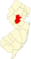
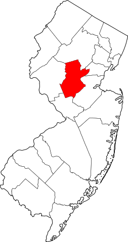
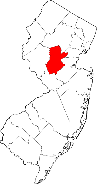
English: This is a locator map showing Somerset County in New Jersey. For more information, see Commons:United States county locator maps. |
| Siku | |
| Ukaboni |
Chinthu chane: English: The maps use data from nationalatlas.gov, specifically countyp020.tar.gz on the Raw Data Download page. The maps also use state outline data from statesp020.tar.gz. The Florida maps use hydrogm020.tar.gz to display Lake Okeechobee. |
| Mlembi | David Benbennick |
Chilolezo
| I, the copyright holder of this work, release this work into the public domain. This applies worldwide. In some countries this may not be legally possible; if so: I grant anyone the right to use this work for any purpose, without any conditions, unless such conditions are required by law. |
Mbili ya chinthu
Dofyani pa siku/nyengo kuti muone umo vikaonekela pa nyengo iyo.
| Siku/Nyengo | Kachithuzi | Vipimo | Mgwiliski | Ganizo | |
|---|---|---|---|---|---|
| sono | 15:29, 12 Febuluwale 2006 | | 1,426 × 2,700 (61 KB) | David Benbennick | {{subst:User:Dbenbenn/clm|county=Somerset County|state=New Jersey|type=county}} |
Magwiliskilo ntchito
The following page uses this file:
Umo chinthu chagwiliskikila ntchito
Ma wiki ghanyake agho ghakugwiliska ichi:
- Magwiliskilo pa ar.wikipedia.org
- Magwiliskilo pa az.wikipedia.org
- Magwiliskilo pa ban.wikipedia.org
- Magwiliskilo pa bg.wikipedia.org
- Magwiliskilo pa bpy.wikipedia.org
- Magwiliskilo pa cdo.wikipedia.org
- Magwiliskilo pa ceb.wikipedia.org
- Magwiliskilo pa ce.wikipedia.org
- Magwiliskilo pa cy.wikipedia.org
- Magwiliskilo pa de.wikipedia.org
- Somerset County (New Jersey)
- Bernardsville
- Bound Brook
- Far Hills
- Manville (New Jersey)
- Millstone (New Jersey)
- North Plainfield
- Peapack-Gladstone
- Raritan (New Jersey)
- Rocky Hill (New Jersey)
- Somerset (New Jersey)
- Somerville (New Jersey)
- South Bound Brook
- Watchung
- Kingston (New Jersey)
- Basking Ridge (New Jersey)
- Vorlage:Navigationsleiste Orte im Somerset County (New Jersey)
- Magwiliskilo pa en.wikipedia.org
Wonani magwiliskilo ghanandi ghapa charu gha chinthu ichi.