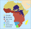
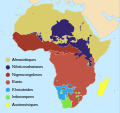
File:Map of African language families.svg

Size of this PNG preview of this SVG file: 635 × 600 pixels. Mu misani inyake: 254 × 240 pixels | 508 × 480 pixels | 813 × 768 pixels | 1,084 × 1,024 pixels | 2,169 × 2,048 pixels | 1,525 × 1,440 pixels.
Chinthu cha kwenekuko (SVG file, nominally 1,525 × 1,440 pixels, file size: 1.05 MB)
Mbili ya chinthu
Dofyani pa siku/nyengo kuti muone umo vikaonekela pa nyengo iyo.
| Siku/Nyengo | Kachithuzi | Vipimo | Mgwiliski | Ganizo | |
|---|---|---|---|---|---|
| sono | 20:52, 2 Okutobala 2023 |  | 1,525 × 1,440 (1.05 MB) | Xavier Dengra | File uploaded using svgtranslate tool (https://svgtranslate.toolforge.org/). Added translation for ca. |
| 02:11, 20 Juni 2023 |  | 1,525 × 1,440 (1.04 MB) | Illchy | File uploaded using svgtranslate tool (https://svgtranslate.toolforge.org/). Added translation for id. | |
| 23:57, 15 Julayi 2017 |  | 1,525 × 1,440 (1.1 MB) | SUM1 | Fixed drop shadows glitch | |
| 23:43, 15 Julayi 2017 |  | 1,525 × 1,440 (1.13 MB) | SUM1 | Fixed Niger–Congo boundary | |
| 20:27, 12 Julayi 2017 |  | 1,525 × 1,440 (1.09 MB) | SUM1 | Fixed Kordofanian boundaries and overlaps | |
| 00:09, 6 Julayi 2017 |  | 1,525 × 1,440 (1.08 MB) | SUM1 | Shifted key closer to continent | |
| 17:14, 5 Julayi 2017 |  | 1,525 × 1,440 (1.08 MB) | SUM1 | Enlarged key | |
| 10:21, 28 Juni 2017 |  | 1,525 × 1,440 (1.08 MB) | SUM1 | Closed gaps in continent, fixed overlaps, fixed rogue colours and removed excess nodes | |
| 01:38, 25 Juni 2017 |  | 1,525 × 1,440 (1.16 MB) | SUM1 | Added drop shadows to bullets and islands | |
| 20:28, 22 Juni 2017 |  | 1,525 × 1,440 (1.11 MB) | SUM1 | Made key circles smaller for readability |
Magwiliskilo ntchito
The following page uses this file:
Umo chinthu chagwiliskikila ntchito
Ma wiki ghanyake agho ghakugwiliska ichi:
- Magwiliskilo pa cy.wikipedia.org
- Magwiliskilo pa en.wikipedia.org
- Magwiliskilo pa fa.wikipedia.org
- Magwiliskilo pa fi.wikipedia.org
- Magwiliskilo pa hy.wikipedia.org
- Magwiliskilo pa id.wikipedia.org
- Magwiliskilo pa mg.wikipedia.org
- Magwiliskilo pa mk.wikipedia.org
- Magwiliskilo pa ps.wikipedia.org
- Magwiliskilo pa sv.wikipedia.org
- Magwiliskilo pa uk.wikipedia.org
- Magwiliskilo pa www.wikidata.org
- Magwiliskilo pa zh-yue.wikipedia.org
- Magwiliskilo pa zh.wikipedia.org


