
File:MalawiOMC.png

Saizi ya chakuona ichi: 288 × 598 pixels. Mu misani inyake: 115 × 240 pixels | 500 × 1,039 pixels.
Chinthu cha kwenekuko (500 × 1,039 pixels, file size: 31 KB, MIME type: image/png)
Mwakudumula
| Malongosolelo | |
| Siku | 9 Ogasiti 2007 (original upload date) |
| Ukaboni | This map's source is here, with the uploader's (User:Kelisi) modifications. |
| Mlembi | |
| Chilolezo (Kugwiliskaso ntchito ichi) |
Original uploader used GFDL; added CC-by-2.5 as per the licensing of the original source map noted above. |
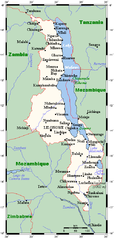
A map showing Malawi sand main towns. This map's source is here, with the uploader's modifications, and the GMT homepage archive copy at the Wayback Machine says that the tools are released under the GNU General Public License.
Chilolezo

|
Chilolezo ntchakupelekeka pakupanga copy, kutandazga panj kusintha na malango gha GNU Free Documentation License, Version 1.2 or any later version published by the Free Software Foundation; with no Invariant Sections, no Front-Cover Texts, and no Back-Cover Texts. A copy of the license is included in the section entitled GNU Free Documentation License. |
| Chinthu ichi ntchakuzomelezgeka na Creative Commons Attribution-Share Alike 3.0 Unported license. | ||
na dango la same or compatible license nga ntchiphya. | ||
| This licensing tag was added to this file as part of the GFDL licensing update. |
This file is licensed under the Creative Commons Attribution 2.5 Generic license.
- Ndimwe ŵakuzomelezgeka:
- kugaŵa – kuti mutandazge, kugaŵa na kusintha ntchito
- kusazga – kusintha chito iyi
- Pa malango ghakulondezga agha:
- Viyambilo vya kuchita – Mukwenela kupeleka malumbo ghawemi, kupeleka linki yakutyonda ku chilolezo, kweneso yowoyaniso pala vinyake vyasintha. Mukwenela kuchita nthena mwakwenelela, kwambula kujikhalila khonde.
Original upload log
The original description page was here. All following user names refer to en.wikipedia.
Transferred to Commons using FtCG.
| Siku/Nyengo | Vipimo | Mgwiliski | Ganizo |
|---|---|---|---|
| 16:42, 9 August 2007 | 500 × 1,039 (32,038 bytes) | w:en:Kelisi (pakuchezgela | Volemba) | (== Summary == A map showing Malawi's cities and main towns. This map's source is [http://www.aquarius.ifm-geomar.de/ here], with the uploader's modifications, and the [http://gmt.soest.hawaii.edu/ GMT homepage] says that the tools are released under the G) |
Mbili ya chinthu
Dofyani pa siku/nyengo kuti muone umo vikaonekela pa nyengo iyo.
| Siku/Nyengo | Kachithuzi | Vipimo | Mgwiliski | Ganizo | |
|---|---|---|---|---|---|
| sono | 18:56, 28 Epulelo 2012 | | 500 × 1,039 (31 KB) | Darkwind | Transferred from en.wikipedia: see original upload log above |
Magwiliskilo ntchito
The following page uses this file:
Umo chinthu chagwiliskikila ntchito
Ma wiki ghanyake agho ghakugwiliska ichi:
- Magwiliskilo pa ar.wikipedia.org
- Magwiliskilo pa en.wikipedia.org
- Magwiliskilo pa ha.wikipedia.org
- Magwiliskilo pa ig.wikipedia.org
- Magwiliskilo pa uk.wikipedia.org