
File:Litorale 1.png
Saizi ya chakuona ichi: 611 × 599 pixels. Mu misani inyake: 245 × 240 pixels | 489 × 480 pixels | 783 × 768 pixels | 1,044 × 1,024 pixels | 2,264 × 2,221 pixels.
Chinthu cha kwenekuko (2,264 × 2,221 pixels, file size: 203 KB, MIME type: image/png)
Mwakudumula
| Malongosolelo |
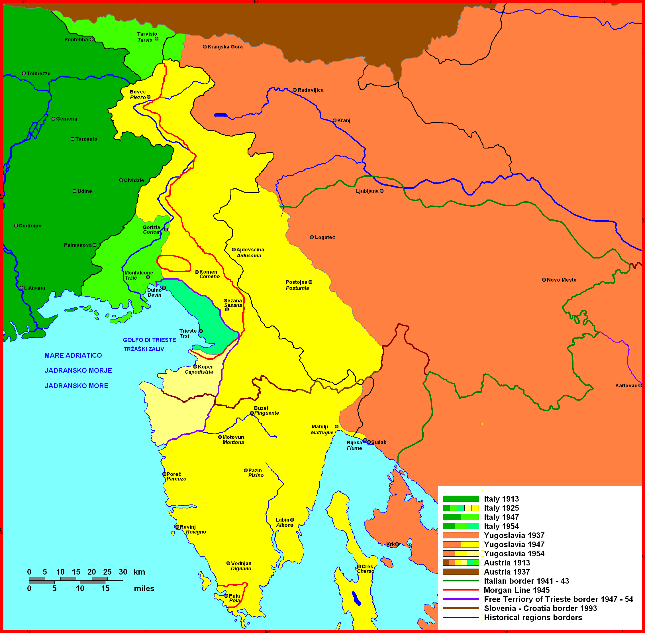
English: Istrian Littoral, map of 20th century history
Čeština: Přímoří, mapa dějin 20. století |
| Siku | |
| Ukaboni | https://www.researchgate.net/publication/270485209_Perception_of_Land_among_Slovenians_in_the_Context_of_Landscape_Changes_in_Slovenian_Istria_Istra |
| Mlembi | Herigona |
| Camera location | | View this and other nearby images on: OpenStreetMap |
|---|
Chilolezo
| I, the copyright holder of this work, release this work into the public domain. This applies worldwide. In some countries this may not be legally possible; if so: I grant anyone the right to use this work for any purpose, without any conditions, unless such conditions are required by law. |
Mbili ya chinthu
Dofyani pa siku/nyengo kuti muone umo vikaonekela pa nyengo iyo.
| Siku/Nyengo | Kachithuzi | Vipimo | Mgwiliski | Ganizo | |
|---|---|---|---|---|---|
| sono | 08:55, 8 Okutobala 2023 | | 2,264 × 2,221 (203 KB) | Tomobe03 | Removed incorrectly placed Cervignano del Friuli label (adds nothing to understanding of overall map) |
| 10:30, 23 Disembala 2014 |  | 2,264 × 2,221 (197 KB) | GCarty | Changed Italian colours to be more easily distinguished | |
| 16:33, 2 Janyuwale 2010 |  | 2,264 × 2,221 (248 KB) | Herigona | Key enlarged; Fiume/Rijeka border modified | |
| 23:05, 29 Disembala 2009 |  | 2,264 × 2,221 (435 KB) | Herigona | {{Information |Description={{en|1=Istrian Littoral, map of 20th century history}} {{cs|1=Přímoří, mapa dějin 20. století}} |{{location dec|45.72152152227954|N|14.39208984375|E}} |Source={{own}} |Date={{Date|2009|12|29}} |Author=[[User:Herigona|Heri |
Magwiliskilo ntchito
The following page uses this file:
Umo chinthu chagwiliskikila ntchito
Ma wiki ghanyake agho ghakugwiliska ichi:
- Magwiliskilo pa an.wikipedia.org
- Magwiliskilo pa ar.wikipedia.org
- Magwiliskilo pa ast.wikipedia.org
- Magwiliskilo pa az.wikipedia.org
- Magwiliskilo pa bs.wikipedia.org
- Magwiliskilo pa ca.wikipedia.org
- Magwiliskilo pa cs.wikipedia.org
- Magwiliskilo pa cy.wikipedia.org
- Magwiliskilo pa de.wikipedia.org
- Magwiliskilo pa en.wikipedia.org
- Istria
- Treaty of Paris between Italy and the Allied Powers
- Treaty of Rapallo (1920)
- Italian irredentism
- Julian March
- Istrian–Dalmatian exodus
- Italian language in Slovenia
- Foibe massacres
- Istrian Italians
- Mutilated victory
- Italian irredentism in Istria
- List of governors of the Province of Trieste
- User:Falcaorib
- Italy (geographical region)
- Magwiliskilo pa es.wikipedia.org
- Magwiliskilo pa gl.wikipedia.org
- Magwiliskilo pa hr.wikipedia.org
- Magwiliskilo pa hu.wikipedia.org
- Magwiliskilo pa it.wikipedia.org
- Provincia di Gorizia
- Fiume (Croazia)
- Pola
- Istria
- Storia di Trieste
- Venezia Giulia
- Quarnaro
- Gorizia
- Trattato di Rapallo (1920)
- Provincia di Pola
- Vittoria mutilata
- Provincia di Trieste
- Lega Nazionale (associazione)
- Trattato di Parigi fra l'Italia e le potenze alleate
- Italiani di Croazia
- Amici e Discendenti degli Esuli Giuliani, Istriani, Fiumani e Dalmati
Wonani magwiliskilo ghanandi ghapa charu gha chinthu ichi.