
File:Kotayk.svg

Size of this PNG preview of this SVG file: 587 × 599 pixels. Mu misani inyake: 235 × 240 pixels | 470 × 480 pixels | 752 × 768 pixels | 1,003 × 1,024 pixels | 2,006 × 2,048 pixels | 725 × 740 pixels.
Chinthu cha kwenekuko (SVG file, nominally 725 × 740 pixels, file size: 72 KB)
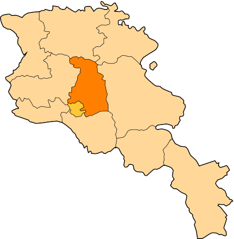
| Malongosolelo | Image shows the eleven administrative subdivisions of Armenia: # Aragatsotn (Արագածոտնի) # Ararat (Արարատի) # Armavir (Արմավիրի) # Gegharkunik (Գեղարքունիքի) # Kotayk (Կոտայքի) # Lori (Լոռու) # Shirak (Շիրակի) # Syunik (Սյունիքի) # Tavush (Տավուշի) # Vayots Dzor (Վայոց Ձորի) # Yerevan (Երևան) - special administrative status Derived from a multiple of public sources and created using Inkscape. == |
| Siku | (UTC) |
| Ukaboni | |
| Mlembi |
|
| This is a retouched picture, which means that it has been digitally altered from its original version. Modifications: Creation d'une autre map. The original can be viewed here: Armenia map numbered.svg:
|
Chinthu ichi ntchakuzomelezgeka na Creative Commons Attribution-Share Alike 3.0 Unported license.
- Ndimwe ŵakuzomelezgeka:
- kugaŵa – kuti mutandazge, kugaŵa na kusintha ntchito
- kusazga – kusintha chito iyi
- Pa malango ghakulondezga agha:
- Viyambilo vya kuchita – Mukwenela kupeleka malumbo ghawemi, kupeleka linki yakutyonda ku chilolezo, kweneso yowoyaniso pala vinyake vyasintha. Mukwenela kuchita nthena mwakwenelela, kwambula kujikhalila khonde.
- mwa kugaŵana – Pala mwasazga panji mwasintha chinthu, mukwenela kuchitandazga
Original upload log
This image is a derivative work of the following images:
- File:Armenia_map_numbered.svg licensed with Cc-by-sa-3.0-migrated, GFDL
- 2010-09-26T17:27:10Z 6AND5 725x740 (82221 Bytes) Reverted to version as of 17:31, 25 November 2006 (((Exclaves deleted according to official map at http://www.gov.am/en/regions/)))
- 2006-11-25T19:37:43Z Bastique 725x740 (87638 Bytes) Cleanup
- 2006-11-25T19:26:57Z Bastique 725x740 (86083 Bytes) Enclaves
- 2006-11-25T17:31:38Z Bastique 725x740 (82221 Bytes) Fixed canvas size
- 2006-11-25T17:27:59Z Bastique 744x1052 (79767 Bytes) Image shows the subdivisions of Armenia. Derived from a multiple of public sources and created using Inkscape. == Licensing == {{GFDL}} Image shows the eleven administrative subdivisions of Armenia: #[[Aragatsotn]] (Ար�
Uploaded with derivativeFX
Mbili ya chinthu
Dofyani pa siku/nyengo kuti muone umo vikaonekela pa nyengo iyo.
| Siku/Nyengo | Kachithuzi | Vipimo | Mgwiliski | Ganizo | |
|---|---|---|---|---|---|
| sono | 11:20, 30 Disembala 2010 | | 725 × 740 (72 KB) | Varmin | {{Information |Description=Image shows the eleven administrative subdivisions of Armenia: # Aragatsotn (Արագածոտնի) # Ararat (Արարատի) # Armavir (Արմավիրի) # Gegharkunik (Գեղ |
Magwiliskilo ntchito
More than 100 pages use this file. The following list shows the first 100 pages that use this file only. A full list is available.
- Abovyan, Ararat
- Aghavnadzor, Kotayk
- Akunk, Kotayk
- Alapars
- Aragyugh
- Araksavan
- Aramus, Armenia
- Ararat (village), Armenia
- Arevshat
- Argel, Armenia
- Arinj
- Armash, Armenia
- Artavaz
- Arzakan
- Arzni
- Avshar, Ararat
- Aygepat
- Aygestan
- Aygezard
- Azatavan
- Baghramyan, Ararat
- Balahovit
- Bardzrashen, Ararat
- Berdik
- Berkanush
- Bjni
- Burastan
- Buzhakan
- Byuravan
- Dalar, Armenia
- Deghdzut
- Dimitrov, Armenia
- Ditak, Armenia
- Dvin, Armenia
- Dzoraghbyur
- Fantan, Armenia
- Garni
- Geghadir, Kotayk
- Geghard, Armenia
- Geghashen
- Getamej
- Getargel
- Getazat
- Goght
- Gorgoch
- Hankavan
- Hatis
- Hatsavan, Kotayk
- Hnaberd, Ararat
- Hovtashen
- Jraber
- Jrarat, Kotayk
- Jrashen, Ararat
- Jrvezh
- Kaghsi
- Kaghtsrashen
- Kakavaberd, Ararat
- Kamaris
- Kanachut
- Kanakeravan
- Kaputan
- Karashamb
- Karenis
- Karki, Azerbaijan
- Kasakh
- Katnaghbyur, Kotayk
- Kotayk (village)
- Lanjar
- Lanjazat
- Lernanist
- Marmarik
- Mayakovski, Armenia
- Meghradzor
- Mrganush
- Mrgashen
- Mrgavan
- Nor Artamet
- Nor Geghi
- Nor Gyugh
- Noyakert
- Nurnus
- Paruyr Sevak, Armenia
- Proshyan
- Ptghni
- Pyunik (village)
- Saralanj, Kotayk
- Sevaberd
- Solak, Armenia
- Surenavan
- Teghenik
- Urtsalanj
- Vardashat
- Verin Ptghni
- Voghjaberd
- Yeraskh
- Zangakatun
- Zar, Armenia
- Zoravan
- Zovashen, Kotayk
- Zovk
View more links to this file.
Umo chinthu chagwiliskikila ntchito
Ma wiki ghanyake agho ghakugwiliska ichi:
- Magwiliskilo pa ar.wikipedia.org
- Magwiliskilo pa be.wikipedia.org
- Magwiliskilo pa bg.wikipedia.org
- Magwiliskilo pa ceb.wikipedia.org
- Magwiliskilo pa ce.wikipedia.org
Wonani magwiliskilo ghanandi ghapa charu gha chinthu ichi.