
File:Kazembe Kingdom 433x455.JPG
Palije saizi ikulu.
Kazembe_Kingdom_433x455.JPG (433 × 455 pixels, file size: 50 KB, MIME type: image/jpeg)
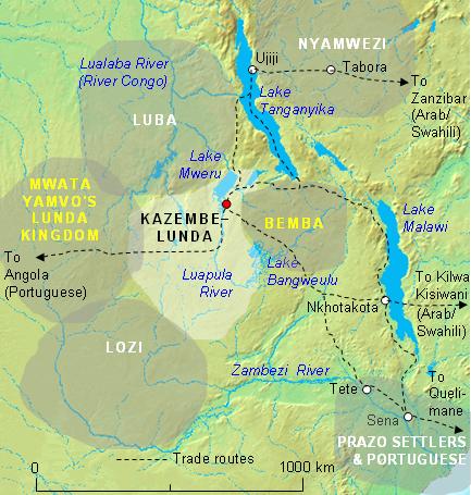
| Malongosolelo | The Kazembe Kingdom (light area, and capital shown as red dot) in its prime in the first half of the 19th Century, before Msiri took south-east Katanga. Boundaries of territories and principal trade routes shown are approximate. See the article on Msiri for the same area in 1880. |
| Siku | |
| Ukaboni | MS Word drawing |
| Mlembi | Rex Parry |
I, the copyright holder of this work, hereby publish it under the following licenses:

|
Chilolezo ntchakupelekeka pakupanga copy, kutandazga panj kusintha na malango gha GNU Free Documentation License, Version 1.2 or any later version published by the Free Software Foundation; with no Invariant Sections, no Front-Cover Texts, and no Back-Cover Texts. A copy of the license is included in the section entitled GNU Free Documentation License. |
| Chinthu ichi ntchakuzomelezgeka na Creative Commons Attribution-Share Alike 3.0 Unported license. | ||
na dango la same or compatible license nga ntchiphya. | ||
| This licensing tag was added to this file as part of the GFDL licensing update. |
This file is licensed under the Creative Commons Attribution 2.5 Generic license.
- Ndimwe ŵakuzomelezgeka:
- kugaŵa – kuti mutandazge, kugaŵa na kusintha ntchito
- kusazga – kusintha chito iyi
- Pa malango ghakulondezga agha:
- Viyambilo vya kuchita – Mukwenela kupeleka malumbo ghawemi, kupeleka linki yakutyonda ku chilolezo, kweneso yowoyaniso pala vinyake vyasintha. Mukwenela kuchita nthena mwakwenelela, kwambula kujikhalila khonde.
You may select the license of your choice.
Mbili ya chinthu
Dofyani pa siku/nyengo kuti muone umo vikaonekela pa nyengo iyo.
| Siku/Nyengo | Kachithuzi | Vipimo | Mgwiliski | Ganizo | |
|---|---|---|---|---|---|
| sono | 02:51, 14 Febuluwale 2007 | | 433 × 455 (50 KB) | Rexparry sydney~commonswiki | The Kazembe Kingdom (light area, and capital shown as red dot) in its prime in the first half of the 19th Century, before Msiri took south-east Katanga. Boundaries of territories and principal trade routes shown are approximate. |
Magwiliskilo ntchito
The following page uses this file:
Umo chinthu chagwiliskikila ntchito
Ma wiki ghanyake agho ghakugwiliska ichi:
- Magwiliskilo pa ca.wikipedia.org
- Magwiliskilo pa en.wikipedia.org
- Magwiliskilo pa es.wikipedia.org
- Magwiliskilo pa fr.wikipedia.org
- Magwiliskilo pa he.wikipedia.org
- Magwiliskilo pa id.wikipedia.org
- Magwiliskilo pa it.wikipedia.org
- Magwiliskilo pa lt.wikipedia.org
- Magwiliskilo pa no.wikipedia.org
- Magwiliskilo pa pt.wikibooks.org
- Magwiliskilo pa uk.wikipedia.org