
File:Dimmitt Tornado1 - NOAA.jpg

Saizi ya chakuona ichi: 800 × 522 pixels. Mu misani inyake: 320 × 209 pixels | 640 × 418 pixels | 1,024 × 669 pixels | 1,280 × 836 pixels | 1,832 × 1,196 pixels.
Chinthu cha kwenekuko (1,832 × 1,196 pixels, file size: 1.13 MB, MIME type: image/jpeg)
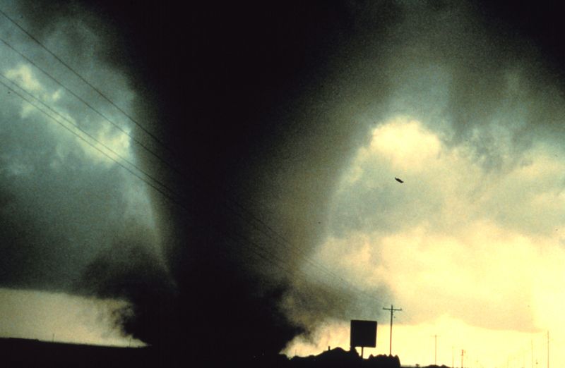
- Description: Project Vortex. The Dimmitt Tornado.
- 'Source: http://www.photolib.noaa.gov/nssl/nssl0177.htm
- 'Image ID: nssl0177, National Severe Storms Laboratory (NSSL) Collection
- 'Location: South of Dimmitt, Texas
- 'Photo Date: June 2, 1995
- 'Photographer: Harald Richter
- 'Credit: NOAA Photo Library, NOAA Central Library; OAR/ERL/National Severe Storms Laboratory (NSSL)
This image is in the public domain because it contains materials that originally came from the U.S. National Oceanic and Atmospheric Administration, taken or made as part of an employee's official duties.
|
Mbili ya chinthu
Dofyani pa siku/nyengo kuti muone umo vikaonekela pa nyengo iyo.
| Siku/Nyengo | Kachithuzi | Vipimo | Mgwiliski | Ganizo | |
|---|---|---|---|---|---|
| sono | 09:16, 11 Novembala 2005 | | 1,832 × 1,196 (1.13 MB) | Saperaud~commonswiki | *'''Description:''' Project Vortex. The Dimmitt Tornado. *''''Source:''' http://www.photolib.noaa.gov/nssl/nssl0177.htm *''''Image ID:''' nssl0177, National Severe Storms Laboratory (NSSL) Collection *''''Location:''' South of Dimmitt, Texas *''''Photo Da |
Magwiliskilo ntchito
The following page uses this file:
Umo chinthu chagwiliskikila ntchito
Ma wiki ghanyake agho ghakugwiliska ichi:
- Magwiliskilo pa cs.wikipedia.org
- Magwiliskilo pa en.wikipedia.org
- Magwiliskilo pa en.wikinews.org
- Magwiliskilo pa he.wikipedia.org
- Magwiliskilo pa hy.wikipedia.org
- Magwiliskilo pa id.wikipedia.org
- Magwiliskilo pa ja.wikipedia.org
- Magwiliskilo pa lv.wikipedia.org
- Magwiliskilo pa nl.wikinews.org
- Magwiliskilo pa ru.wikipedia.org
- Magwiliskilo pa simple.wikipedia.org
- Magwiliskilo pa si.wikipedia.org
- Magwiliskilo pa sk.wikipedia.org
- Magwiliskilo pa uk.wikipedia.org