
File:Confederate States of America.svg

Size of this PNG preview of this SVG file: 800 × 501 pixels. Mu misani inyake: 320 × 200 pixels | 640 × 401 pixels | 1,024 × 642 pixels | 1,280 × 802 pixels | 2,560 × 1,604 pixels | 913 × 572 pixels.
Chinthu cha kwenekuko (Animated SVG file, nominally 913 × 572 pixels, file size: 57 KB)
Note: Due to technical limitations, thumbnails of this file will not be animated.
Mwakudumula
| Malongosolelo |
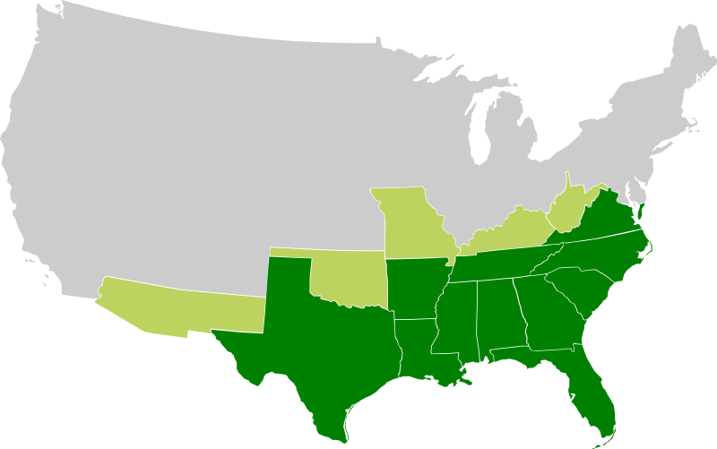
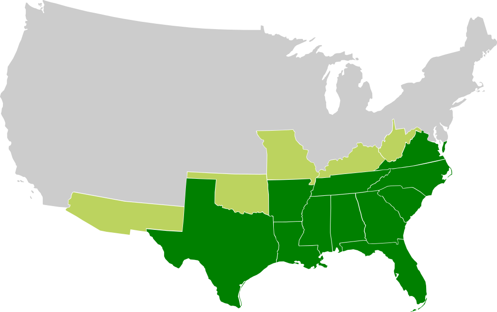
A map of the Confederate States of America, Maryland and claimed states and territories.
States that seceeded under CSA control
States and territories claimed by CSA without formal secession and/or control |
| Siku | |
| Ukaboni | Chinthu chane |
| Mlembi |
|
| Other versions | File:Csa5-3.gif |
Chilolezo
Chinthu ichi ntchakuzomelezgeka na Creative Commons Attribution-Share Alike 3.0 Unported license.
- Ndimwe ŵakuzomelezgeka:
- kugaŵa – kuti mutandazge, kugaŵa na kusintha ntchito
- kusazga – kusintha chito iyi
- Pa malango ghakulondezga agha:
- Viyambilo vya kuchita – Mukwenela kupeleka malumbo ghawemi, kupeleka linki yakutyonda ku chilolezo, kweneso yowoyaniso pala vinyake vyasintha. Mukwenela kuchita nthena mwakwenelela, kwambula kujikhalila khonde.
- mwa kugaŵana – Pala mwasazga panji mwasintha chinthu, mukwenela kuchitandazga
Mbili ya chinthu
Dofyani pa siku/nyengo kuti muone umo vikaonekela pa nyengo iyo.
| Siku/Nyengo | Kachithuzi | Vipimo | Mgwiliski | Ganizo | |
|---|---|---|---|---|---|
| sono | 16:23, 27 Novembala 2009 | | 913 × 572 (57 KB) | Lexicon | Reverted to version as of 08:57, 21 March 2008 as new version is different image used for different purposes, and not an SVG file |
| 00:56, 26 Novembala 2009 |  | 640 × 419 (34 KB) | Major General Sterling Price | this is the Confederate States today if they won the Civil War | |
| 08:57, 21 Malichi 2008 |  | 913 × 572 (57 KB) | Nkocharh | I forgot Kentucky! | |
| 08:49, 21 Malichi 2008 |  | 913 × 572 (55 KB) | Nkocharh | {{Information |Description=A map of the Confederate Sates of America |Source=self-made |Date=21 March 2008 |Author= Nkocharh |Permission= |other_versions= }} |
Magwiliskilo ntchito
The following 2 pages use this file:
Umo chinthu chagwiliskikila ntchito
Ma wiki ghanyake agho ghakugwiliska ichi:
- Magwiliskilo pa af.wikipedia.org
- Magwiliskilo pa arz.wikipedia.org
- Magwiliskilo pa bn.wikipedia.org
- Magwiliskilo pa br.wikipedia.org
- Magwiliskilo pa da.wikipedia.org
- Magwiliskilo pa de.wikipedia.org
- Magwiliskilo pa el.wikipedia.org
- Magwiliskilo pa en.wikipedia.org
- Alabama
- Arkansas
- Confederate States of America
- Louisiana
- North Carolina
- South Carolina
- Texas
- Tennessee
- Virginia
- West Virginia
- Georgia (U.S. state)
- Confederate Arizona
- West Virginia in the American Civil War
- User:Nkocharh
- Missouri in the American Civil War
- Florida in the American Civil War
- Kentucky in the American Civil War
- Alabama in the American Civil War
- Mississippi in the American Civil War
- South Carolina in the American Civil War
- Tennessee in the American Civil War
- Texas in the American Civil War
- Georgia in the American Civil War
- North Carolina in the American Civil War
- Virginia in the American Civil War
- Template:Confederate States political divisions
- Arkansas in the American Civil War
- Louisiana in the American Civil War
- Confederate government of Kentucky
- Wikipedia:Graphics Lab/Images to improve/Archive/Mar 2008
- Mississippi
- Secession in the United States
- Florida
- Conclusion of the American Civil War
- 1861 in the United States
- Talk:Muscogee Nation
- Confederate government of Missouri
Wonani magwiliskilo ghanandi ghapa charu gha chinthu ichi.