
File:Australia relief map.jpg

Saizi ya chakuona ichi: 668 × 600 pixels. Mu misani inyake: 267 × 240 pixels | 534 × 480 pixels | 855 × 768 pixels | 1,140 × 1,024 pixels | 1,336 × 1,200 pixels.
Chinthu cha kwenekuko (1,336 × 1,200 pixels, file size: 366 KB, MIME type: image/jpeg)
Mwakudumula
| Malongosolelo |
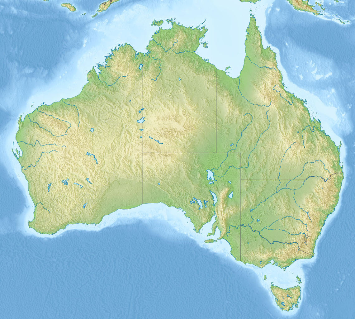
English: Relief map of Australia, including the borders of the states of the Commonwealth of Australia
Equirectangular projection, N/S stretching 110 %. Geographic limits of the map:
|
| Siku | |
| Ukaboni |
|
| Mlembi | |
| Other versions |
Derivative works of this file: Skylab reentry map.svg |

Chilolezo
Chinthu ichi ntchakuzomelezgeka na Creative Commons Attribution-Share Alike 3.0 Unported license.
- Ndimwe ŵakuzomelezgeka:
- kugaŵa – kuti mutandazge, kugaŵa na kusintha ntchito
- kusazga – kusintha chito iyi
- Pa malango ghakulondezga agha:
- Viyambilo vya kuchita – Mukwenela kupeleka malumbo ghawemi, kupeleka linki yakutyonda ku chilolezo, kweneso yowoyaniso pala vinyake vyasintha. Mukwenela kuchita nthena mwakwenelela, kwambula kujikhalila khonde.
- mwa kugaŵana – Pala mwasazga panji mwasintha chinthu, mukwenela kuchitandazga
Mbili ya chinthu
Dofyani pa siku/nyengo kuti muone umo vikaonekela pa nyengo iyo.
| Siku/Nyengo | Kachithuzi | Vipimo | Mgwiliski | Ganizo | |
|---|---|---|---|---|---|
| sono | 07:38, 14 Novembala 2010 | | 1,336 × 1,200 (366 KB) | Виктор В | == {{int:filedesc}} == {{Information |Description={{en|Relief map of Australia}} Equirectangular projection, N/S stretching 110 %. Geographic limits of the map: * N: 9.0° S * S: 44.5° S * W: 111.5° E * E: 155.0° E |Source=* [[:File:A |
Magwiliskilo ntchito
The following 2 pages use this file:
Umo chinthu chagwiliskikila ntchito
Ma wiki ghanyake agho ghakugwiliska ichi:
- Magwiliskilo pa ab.wikipedia.org
- Magwiliskilo pa als.wikipedia.org
- Magwiliskilo pa am.wikipedia.org
- Magwiliskilo pa ar.wikipedia.org
- Magwiliskilo pa arz.wikipedia.org
- Magwiliskilo pa ast.wikipedia.org
- Magwiliskilo pa as.wikipedia.org
- Magwiliskilo pa azb.wikipedia.org
- Magwiliskilo pa az.wikipedia.org
- Böyük Suayırıcı sıra dağları
- Liverpul (dağ)
- Böyük Viktoriya səhrası
- Tasman dənizi
- Timor dənizi
- Eyr
- Uluru
- Hiller gölü
- Kakadu Milli Parkı
- Uluru–Kata-Tyuta Milli Parkı
- Purnululu Milli Parkı
- Şablon:Yer xəritəsi Avstraliya
- Freyzer (ada)
- Mərcan dənizi
- Kostyuşko (dağ)
- Bass boğazı
- Karpentariya körfəzi
- Spenser körfəzi
- Torres boğazı
- Dundas boğazı
- Tasman yarımadası
- Yanakie bərzəxi
- D'Antrkasto boğazı
- Undara Vulkanik Milli Parkı
- Kalbarri Milli Parkı
- Böyük Avstraliya körfəzi
- Torrens gölü
- Melvill (ada, Avstraliya)
- Bayron burnu
- York burnu (Avstraliya)
- Saut-Poynt
- Stip-Poynt burnu
- Böyük Qumlu səhra
- Kiçik Qumlu səhra
Wonani magwiliskilo ghanandi ghapa charu gha chinthu ichi.