
File:Ausangate-hillside-MT.jpg

Saizi ya chakuona ichi: 800 × 516 pixels. Mu misani inyake: 320 × 206 pixels | 640 × 413 pixels | 1,024 × 661 pixels | 1,550 × 1,000 pixels.
Chinthu cha kwenekuko (1,550 × 1,000 pixels, file size: 1.01 MB, MIME type: image/jpeg)
Mwakudumula
| Malongosolelo |
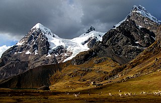
English: Hillside of peruvian Ausangate mountain.
Čeština: Úbočí peruánské hory Ausangate.
Deutsch: Standort südlich des Lago Uchuy Pucacocha; Blick nach Norden auf die westlichen Vorberge des Nevado Ausangate |
| Siku | |
| Ukaboni | Chinthu chane |
| Mlembi | Marturius |
| Camera location | | View this and other nearby images on: OpenStreetMap |
|---|
Chilolezo
I, the copyright holder of this work, hereby publish it under the following licenses:
Chinthu ichi ntchakuzomelezgeka na Creative Commons Attribution-Share Alike 3.0 Unported license.
- Ndimwe ŵakuzomelezgeka:
- kugaŵa – kuti mutandazge, kugaŵa na kusintha ntchito
- kusazga – kusintha chito iyi
- Pa malango ghakulondezga agha:
- Viyambilo vya kuchita – Mukwenela kupeleka malumbo ghawemi, kupeleka linki yakutyonda ku chilolezo, kweneso yowoyaniso pala vinyake vyasintha. Mukwenela kuchita nthena mwakwenelela, kwambula kujikhalila khonde.
- mwa kugaŵana – Pala mwasazga panji mwasintha chinthu, mukwenela kuchitandazga

|
Chilolezo ntchakupelekeka pakupanga copy, kutandazga panj kusintha na malango gha GNU Free Documentation License, Version 1.2 or any later version published by the Free Software Foundation; with no Invariant Sections, no Front-Cover Texts, and no Back-Cover Texts. A copy of the license is included in the section entitled GNU Free Documentation License. |
You may select the license of your choice.
Mbili ya chinthu
Dofyani pa siku/nyengo kuti muone umo vikaonekela pa nyengo iyo.
| Siku/Nyengo | Kachithuzi | Vipimo | Mgwiliski | Ganizo | |
|---|---|---|---|---|---|
| sono | 17:18, 26 Janyuwale 2010 | | 1,550 × 1,000 (1.01 MB) | Marturius | {{Information |Description={{en|1=Hillside of peruvian Ausangate mountain.}} {{cs|1=Úbočí peruánské hory Ausangate.}} |Source={{own}} |Author=Marturius |Date=2008 |Permission= |other_versions= }} Category:Peruvian mountains [[ |
Magwiliskilo ntchito
The following page uses this file:
Umo chinthu chagwiliskikila ntchito
Ma wiki ghanyake agho ghakugwiliska ichi:
- Magwiliskilo pa ang.wikipedia.org
- Magwiliskilo pa arc.wikipedia.org
- Magwiliskilo pa ar.wikipedia.org
- Magwiliskilo pa ay.wikipedia.org
- Magwiliskilo pa bs.wikipedia.org
- Magwiliskilo pa ceb.wikipedia.org
- Magwiliskilo pa cy.wikipedia.org
- Magwiliskilo pa en.wikipedia.org
- Andes
- Llama
- Quechuan languages
- Nevado del Ruiz
- Misti
- Tungurahua
- Andean Community
- Chimborazo
- Cotopaxi
- Pichincha (volcano)
- Mérida (state)
- Táchira
- Trujillo (state)
- Vicuña
- Illiniza
- Cayambe (volcano)
- Siula Grande
- Cordillera Huayhuash
- Alpamayo
- Andean mountain cat
- Spectacled bear
- Cordillera Blanca
- Cerro Escorial
- Huascarán
- Telmatobius
- Sangay
- Quechua people
- Huayna Potosí
- Antisana
- Reventador
- Fitz Roy
- El Chaltén
- University of the Andes (Venezuela)
Wonani magwiliskilo ghanandi ghapa charu gha chinthu ichi.