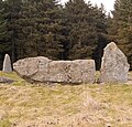
File:Aikey Brae Stone Circle recumbent cropped from geograph.org.uk - 1774962 (cropped).jpg

Page contents not supported in other languages.
Kufuma Wikipedia

Chinthu cha kwenekuko(786 × 751 pixels, file size: 261 KB, MIME type: image/jpeg)

Chinthu ichi ntchaku Wikimedia Commons ndipo chingagwiliskikaso kunyake. Vakulongosola vake file description page vili pasi apa.

Mwakudumula

Malongosolelo
English: Aikey Brae Stone Circle Thought to be about 4,000 years old, this stone circle was possibly used to track lunar cycles.
Siku
Ukaboni This file was derived from: Aikey Brae Stone Circle - geograph.org.uk - 1774962.jpg
Mlembi
Other versions
image extraction process
This file has been extracted from another file
: Aikey Brae Stone Circle - geograph.org.uk - 1774962.jpg
original file
Attribution
(required by the license)
InfoField
Bill Harrison / Aikey Brae Stone Circle / 
Bill Harrison / Aikey Brae Stone Circle
Camera location57° 30′ 49″ N, 2° 04′ 15″ W  Heading=45° Kartographer map based on OpenStreetMap.View this and other nearby images on: OpenStreetMapinfo
Object location57° 30′ 50″ N, 2° 04′ 13″ W  Heading=45° Kartographer map based on OpenStreetMap.View this and other nearby images on: OpenStreetMapinfo

Chilolezo

w:en:Creative Commons
Viyambilo vya kuchita mwa kugaŵana
This file is licensed under the Creative Commons Attribution-Share Alike 2.0 Generic license.
Attribution: Bill Harrison
Ndimwe ŵakuzomelezgeka:
  • kugaŵa – kuti mutandazge, kugaŵa na kusintha ntchito
  • kusazga – kusintha chito iyi
Pa malango ghakulondezga agha:
  • Viyambilo vya kuchita – Mukwenela kupeleka malumbo ghawemi, kupeleka linki yakutyonda ku chilolezo, kweneso yowoyaniso pala vinyake vyasintha. Mukwenela kuchita nthena mwakwenelela, kwambula kujikhalila khonde.
  • mwa kugaŵana – Pala mwasazga panji mwasintha chinthu, mukwenela kuchitandazga
na dango la same or compatible license nga ntchiphya.

Captions

Add a one-line explanation of what this file represents
The 21.5 tonne recumbent stone (centre) at Aikey Brae

Items portrayed in this file

depicts English

copyrighted English

inception English

21 Malichi 2010

57°30'49.50"N, 2°4'14.52"W

heading English: 45.0 degree

57°30'50.15"N, 2°4'12.72"W

heading English: 45 degree

media type English

image/jpeg

checksum English

2a3db275076597a294137991466731aa70420388

determination method English: SHA-1 English

data size English

267,366 byte

height English

751 pixel

width English

786 pixel

Mbili ya chinthu

Dofyani pa siku/nyengo kuti muone umo vikaonekela pa nyengo iyo.

Siku/NyengoKachithuziVipimoMgwiliskiGanizo
sono15:45, 20 Disembala 2020Kachithuzi kachoko nga mpha 15:45, 20 Disembala 2020786 × 751 (261 KB)MujingaFile:Aikey Brae Stone Circle - geograph.org.uk - 1774962.jpg cropped 51 % horizontally, 29 % vertically using CropTool with precise mode.

The following page uses this file:

Umo chinthu chagwiliskikila ntchito