File:African-civilizations-map-pre-colonial.svg
Page contents not supported in other languages.
Kufuma Wikipedia

Chinthu cha kwenekuko(SVG file, nominally 1,390 × 1,295 pixels, file size: 488 KB)

Chinthu ichi ntchaku Wikimedia Commons ndipo chingagwiliskikaso kunyake. Vakulongosola vake file description page vili pasi apa.

 
W3C-validity not checked.

Mwakudumula

Malongosolelo

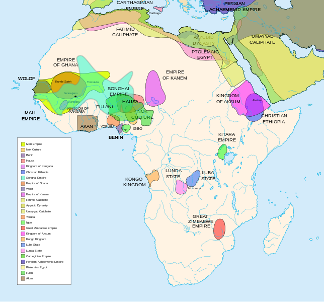
Africa History Atlas

Diachronic map showing pre-colonial cultures of Africa (spanning roughly 500 BCE to 1500 CE)

This map is "an artistic interpretation" using multiple and disparate sources.
Siku
Ukaboni Chinthu chane
Mlembi Jeff Israel (ZyMOS)
Other versions

Derivative works of this file:  African-civilizations-map-imperial.png

Civilizations

These civilizations are shown on the map above

Mali Empire (done):
        [4], [5], [6], [7], [8](1300), 14

Nok Culture(done):
        http://perso.orange.fr/miltiade/Civilisation_de_Nok.htm
        [5]

Fulani empire (aka sokoto empire, Sokoto Calphate, Fulani Empire of Sokoto)  (fulani people are different) (done):
        [2], [10e], [11e]
Akan States (generric term for states with the akan people)(Done): 
 [7], 
Benin: (done)
        [7],[14],[16]
Hausa (done)
        [7], [10],[16]

Kingdon of Kangaba (1000AD?) (done)
        [8](1235)

Christian Ethiopia(done)
        [5]

Songhai Empire (done)
        http://commons.wikimedia.org/wiki/Image:Mapa_shonghai.svg
        [3], [4], [5], [6], [7], [8](1300), [16]
        http://www.zum.de/whkmla/histatlas/westafrica/haxmali.html
        http://empathosnationenterprises.com/Consulate/EN-Library/Black-Studies/afempire.html

Empire of Ghana (done):
        [4], [5], [6], [7]

Wolof: (15th century) (done)
        [2],[2c],[14]

Empire of Kanem:(done)
        [15]

Fatimid caliphate(done) 909-1171AD
        [2b],[6b]

Ayyubid dynasty (done) 1171-1250ad
        [1b], [5e], [6e]

Umayyad Caliphate (done) 661-750
        [5b]

Yoruba yorubaland    (done)
        [4b],[2c]

Igbo    (done)
        [4b],

Great Zimbabwe (done):
        [5], [7]

Kingdom of aksum (Axum?) 1bc-7ad  (done)
        [12b],[14b],[15b]

Kongo Kingdom     (done)
        [1c], [2c],[15]

Luba State (done) 15-19th century
        [2c],[4c]

Lunda State (done) 15-19th century
        [2c],[4c],[16]

Carthaginian Empire(done) (220BCE) Carthage
        [2c], [3c]

Persian Achaemenid Empire (done)
        [2e],3e].4e],[

THE PTOLEMIES (done)
        [8e], [9e]

Civilizations to be added

These civilizations have not been added because the borders have not yet been confirmed, or there is some uncertainty if they are a true civilization. Please add them to the map if you are able to define the borders of these civilizations.


Mane (1000-2000)(city) [41]

Kano (independent city-state) (1000-1903):
 [14]

Kaarta (kingdom of Kaarta) (1753-1854):
 [14]

Macina (Macina Empire) (aka Dina of Massina, Sise Jihad state, and Caliphate of Hamdullahi) (1818-1862):
 [14]

Segou (city 1620):
 [14]

Kingdom of Fouta Djallon (Futa Djalon or Kingdom of Fuuta Jallon):
 [14]

Hausa Bakwai (initial stage Hausa):
 [11e]

Wassoulou Empire (Ouassoulou) (1878 - 1898) :
 [14]

Kénédougou Kingdom (Kenedougou) (1650-1898):
 [14]

Ouagadougou (15th century CITY):
 [14]

Ashanti Kingdom:
	[14]

Dahomey:
	[14]

Gando (16th century town):
	[14]

kingdom of Takrur (c. 800 - c. 1285) :
	[8](1300), [13]

Oyo empire (1400-1796)


Bornu Empire (1396-1893):
        [2],[15], [10e]

Bornu-Kanem (a portion of kanem history where they merged):
	[7],[2c]

Wodaabe (a people of africa):
	[10]

Mamluk Sultanate of Egypt (1174-1820):
	[2],[12], 

Kush?Kushite kingdom?:

Axum (see kingdom of aksum):

Buganda kingdom (changed to Unganda, but remained as Buganda people):

Lozi???:

Malawi Empire (late 15th centure and converted to Malawi Contry):

Kilwa (Kilwa Kisiwani, 9th century,  is an Islamic community is present day tanzania):
	[2c]

Abyssinia???:
        [2], [7]

Soha????:
        [2],

Nubia (Makuria, Nobatia, Alodia kingdom):
	[7], 

Kingdom of Kerma(2500BC-1520BC):

=North Central=

Sahariano??:
	[1], 

Maban????????:
        [1],

Fur(a people:
        [1],

Sudanes Central (language Central Sudanic):
        [1],

=East Central=

Sudanes Meridional???:
        [1],

Berta(language>:
        [1],

Kunama(a people):
        [1],

Komuz???instument:
        [1],

Aksumite Civilization
	[7b], [9b(maybey], [13b(aksum)]

Kingdom of Sheva???
	[8b]

Egypt
	[10b]

JolofEmpire (also called Dyolof or Wolof), wolof should be changed to this:
	[11b]


Meroe(city, capital of Kushitic Kingdom)) 
	[12b]

Bantu(ethnic group)
	[12b]

Khoisan(ethnic group)
	[12b]

Almoravid Empire
	[5c], [1f]
	
Monomotapa
	[2c],[16]

Lozi
	[2c]

Zulu Kingdom
	[2c]

Merina
	[2c]

Malawi
	[2c]

Rawanda
	[2c]

Buganada
	[2c]

Kazembe
	[4c]


Punt (3000BC-1000BC):
	location lost in time

D'mt (800BC-100BC):


Gudit (1000AD):

Zagwe Dynasty (1000-1268AD):
	[6e]
	
Solomonic dynasty (1270-1974AD)

Himyar:
	[1d]

Qataban:
	[1d]

Saba:
	[1d]

Hadhramaut:
	[1d]

Thutmoses 1
	[1e]

Ramesses II
	[1e]

Assurbanipal, empire of 
	[7e]

Mbunda Kingdom
	[12e], [13e]

Editing this page and map

Suggestions before editing this map: Be sure to confirm it with multiple sources, and that it would be considered a true civilization. Also if you add to the map please name the layers and objects to keep it organized. A lot of the civilizations on this page do not have the times they existed. If this could be added it would be very beneficial. Then the map could be easily split into eras.

References

The original map came from


Chilolezo

I, the copyright holder of this work, hereby publish it under the following licenses:
GNU head Chilolezo ntchakupelekeka pakupanga copy, kutandazga panj kusintha na malango gha GNU Free Documentation License, Version 1.2 or any later version published by the Free Software Foundation; with no Invariant Sections, no Front-Cover Texts, and no Back-Cover Texts. A copy of the license is included in the section entitled GNU Free Documentation License.
w:en:Creative Commons
Viyambilo vya kuchita mwa kugaŵana
This file is licensed under the Creative Commons Attribution-Share Alike 3.0 Unported, 2.5 Generic, 2.0 Generic and 1.0 Generic license.
Ndimwe ŵakuzomelezgeka:
  • kugaŵa – kuti mutandazge, kugaŵa na kusintha ntchito
  • kusazga – kusintha chito iyi
Pa malango ghakulondezga agha:
  • Viyambilo vya kuchita – Mukwenela kupeleka malumbo ghawemi, kupeleka linki yakutyonda ku chilolezo, kweneso yowoyaniso pala vinyake vyasintha. Mukwenela kuchita nthena mwakwenelela, kwambula kujikhalila khonde.
  • mwa kugaŵana – Pala mwasazga panji mwasintha chinthu, mukwenela kuchitandazga
na dango la same or compatible license nga ntchiphya.
You may select the license of your choice.

Captions

Add a one-line explanation of what this file represents
Map of pre-colonial African civilizations

Items portrayed in this file

depicts English

map English

copyrighted English

inception English

1 Meyi 2007

media type English

image/svg+xml

checksum English

458dcae2fb4eb4a66837ee9cd5c1e539750e7c18

determination method English: SHA-1 English

data size English

498,775 byte

height English

1,295 pixel

width English

1,390 pixel

Mbili ya chinthu

Dofyani pa siku/nyengo kuti muone umo vikaonekela pa nyengo iyo.

(newest | oldest) Wonani (newer 10 | ) (10 | 20 | 50 | 100 | 250 | 500)
Siku/NyengoKachithuziVipimoMgwiliskiGanizo
sono06:49, 16 Febuluwale 2024Kachithuzi kachoko nga mpha 06:49, 16 Febuluwale 20241,390 × 1,295 (488 KB)Ahiise2Changed "Bachwezi Empire" to "Kitara Empire" to be consistent with other versions of the file
04:11, 20 Sekutembala 2011Kachithuzi kachoko nga mpha 04:11, 20 Sekutembala 20111,390 × 1,295 (487 KB)Alphathonmoved rivers to the top
03:33, 20 Sekutembala 2011Kachithuzi kachoko nga mpha 03:33, 20 Sekutembala 20111,390 × 1,295 (487 KB)AlphathonOne more time…
03:27, 20 Sekutembala 2011Kachithuzi kachoko nga mpha 03:27, 20 Sekutembala 20111,390 × 1,295 (486 KB)AlphathonFound some more errors
03:16, 20 Sekutembala 2011Kachithuzi kachoko nga mpha 03:16, 20 Sekutembala 20111,390 × 1,295 (489 KB)AlphathonSome final clean-ups and fixes
02:59, 20 Sekutembala 2011Kachithuzi kachoko nga mpha 02:59, 20 Sekutembala 20111,390 × 1,295 (471 KB)AlphathonApparently I duped The Persian Archaemenid Empire (now fixed). Also fixed borders of said empire.
02:50, 20 Sekutembala 2011Kachithuzi kachoko nga mpha 02:50, 20 Sekutembala 20111,390 × 1,295 (452 KB)AlphathonReinstated "Akan" on proper vector version of the map and tidied up some sea-borders (some still need looking at)
02:02, 20 Sekutembala 2011Kachithuzi kachoko nga mpha 02:02, 20 Sekutembala 20111,390 × 1,295 (297 KB)AlphathonReverted to version as of 22:11, 20 July 2010 - previous version was not a vector image
17:42, 26 Malichi 2011Kachithuzi kachoko nga mpha 17:42, 26 Malichi 20112,000 × 1,863 (2.66 MB)Medicineman84== {{int:filedesc}} == {{Information |Description=Africa History Atlas Diachronic map showing pre-colonial cultures of Africa (spanning roughly 500 BCE to 1500 CE) This map is "an artistic interpretation" using multiple and disparate sources. |Source={
22:11, 20 Julayi 2010Kachithuzi kachoko nga mpha 22:11, 20 Julayi 20101,390 × 1,295 (297 KB)Ras67font fault resolved
(newest | oldest) Wonani (newer 10 | ) (10 | 20 | 50 | 100 | 250 | 500)

The following 4 pages use this file:

Umo chinthu chagwiliskikila ntchito

Ma wiki ghanyake agho ghakugwiliska ichi:

Wonani magwiliskilo ghanandi ghapa charu gha chinthu ichi.

Metadata