
File:Un-malawi.png
Chinthu cha kwenekuko (2,057 × 2,820 pixels, file size: 1.19 MB, MIME type: image/png)
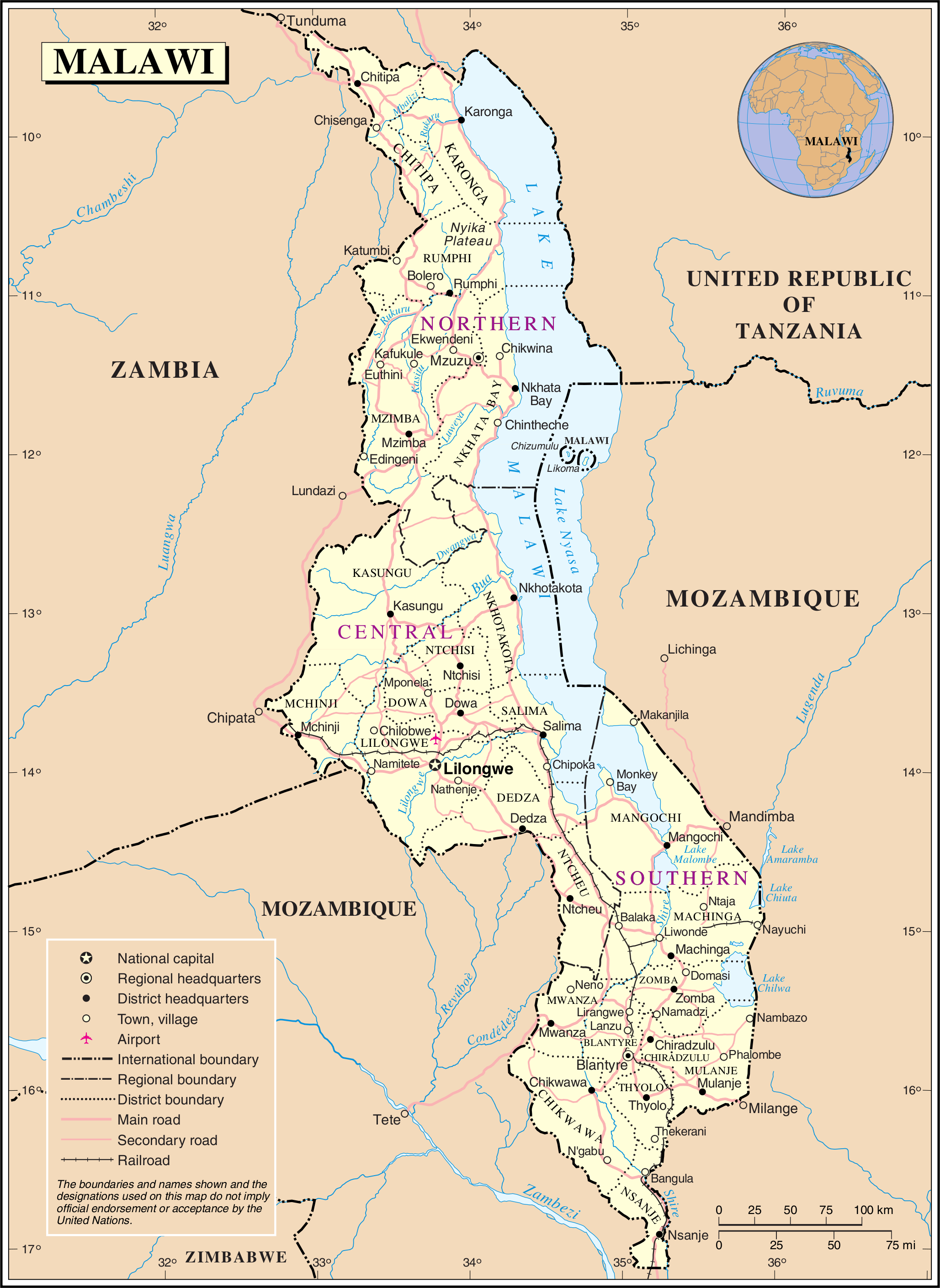
| This image is a map derived from a United Nations map.
Unless stated otherwise, UN maps are to be considered in the public domain. This applies worldwide. UN maps are, in principle, open source material and you can use them in your work or for making your own map. UN requests however that you delete the UN name, logo and reference number upon any modification to the map. Content of your map will be your responsibility. You can state in your publication, if you wish, something like: based on UN map … (map name, map number, revision number and date). See: Geospatial Information Section. And: Geospatial, location data for a better world. |
 |
Mbili ya chinthu
Dofyani pa siku/nyengo kuti muone umo vikaonekela pa nyengo iyo.
| Siku/Nyengo | Kachithuzi | Vipimo | Mgwiliski | Ganizo | |
|---|---|---|---|---|---|
| sono | 01:30, 24 Okutobala 2007 | | 2,057 × 2,820 (1.19 MB) | Jeroen | {{UN map}} Category:Maps of Malawi |
Magwiliskilo ntchito
The following 3 pages use this file:
Umo chinthu chagwiliskikila ntchito
Ma wiki ghanyake agho ghakugwiliska ichi:
- Magwiliskilo pa ast.wikipedia.org
- Magwiliskilo pa az.wikipedia.org
- Magwiliskilo pa de.wikipedia.org
- Magwiliskilo pa en.wikipedia.org
- Magwiliskilo pa eo.wikipedia.org
- Magwiliskilo pa es.wikipedia.org
- Magwiliskilo pa fr.wikipedia.org
- Magwiliskilo pa it.wikipedia.org
- Magwiliskilo pa ja.wikipedia.org
- Magwiliskilo pa ko.wikipedia.org
- Magwiliskilo pa lt.wikipedia.org
- Magwiliskilo pa mt.wikipedia.org
- Magwiliskilo pa nds.wikipedia.org
- Magwiliskilo pa nl.wikipedia.org
- Magwiliskilo pa no.wikipedia.org
- Magwiliskilo pa pl.wiktionary.org
- Magwiliskilo pa ro.wikipedia.org
- Magwiliskilo pa ru.wikipedia.org
- Magwiliskilo pa uk.wikipedia.org
- Magwiliskilo pa vls.wikipedia.org
- Magwiliskilo pa zea.wikipedia.org