
File:Nigeria (orthographic projection).svg

Size of this PNG preview of this SVG file: 553 × 553 pixels. Mu misani inyake: 240 × 240 pixels | 480 × 480 pixels | 768 × 768 pixels | 1,024 × 1,024 pixels | 2,048 × 2,048 pixels.
Chinthu cha kwenekuko (SVG file, nominally 553 × 553 pixels, file size: 218 KB)
Mwakudumula
| Malongosolelo |
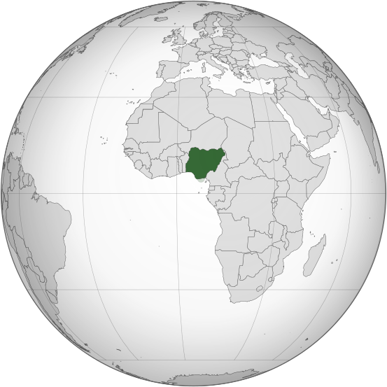
English: Orthographic map of Nigeria |
| Siku | |
| Ukaboni | Chinthu chane |
| Mlembi | Ukabia |
| Other versions |
.svg) |
.svg)
.svg)
.svg)
.svg)
.svg)
.svg)
.svg)
.svg)
.svg)
.svg)
.svg)
.svg)
.svg)
.svg)
.svg)
.svg)
.svg)
.svg)
.svg)
.svg)
.svg)
.svg)
.svg)
.svg)
.svg)
.svg)
.svg)
.svg)
.svg)
.svg)
.svg)
.svg)
.svg)
.svg)
.svg)
.svg)
.svg)
.svg)
.svg)
.svg)
.svg)
.svg)
.svg)
.svg)
.svg)
.svg)
.svg)
.svg)
.svg)
.svg)
.svg)
.svg)
.svg)
.svg)
.svg)
.svg)
.svg)
.svg)
.svg)
.svg)
.svg)
.svg)
.svg)
.svg)
.svg)
.svg)
.svg)
.svg)
.svg)
.svg)
.svg)
.svg)
.svg)

.svg)

.svg)

.svg)
.svg)
.svg)
.svg)
.svg)
.svg)
.svg)


.svg)
.svg)
.svg)
.svg)
.svg)
.svg)
.svg)

.svg)
.svg)
.svg)
.svg)
.svg)
.svg)
.svg)
.svg)
.svg)

.svg)
.svg)
.svg)
.svg)
.svg)
.svg)
.svg)
_without_national_boundaries.svg)
.svg)
.svg)
.svg)
.svg)
.svg)
.svg)

.svg)
.svg)
.png)
.svg)
.svg)
.svg)
.svg)

.svg)
.svg)
.svg)
.svg)
.svg)
.svg)
.svg)
.svg)
.svg)
.svg)
.svg)

.svg)
.svg)
.svg)
.svg)
.svg)
.svg)
.svg)
.svg)
.svg)

.svg)
.svg)

.svg)
.svg)
.svg)
.svg)
.svg)
.svg)
.svg)
.svg)
.svg)
.svg)
.svg)
.svg)
.svg)
.svg)
.svg)
.svg)
.svg)
.svg)
.svg)
.svg)
.svg)
.svg)
.svg)
.svg)
.svg)
.svg)
.svg)
_-_Crimea_disputed.svg)
.svg)
.svg)
.svg)
.svg)
.svg)
.svg)
.svg)
.svg)
.svg)
.svg)
.svg)
_political.svg)
.svg)
.svg)
.svg)
.svg)
_-_Crimea_disputed_-_no_borders.svg)
.svg)
.svg)
.svg)
.svg)
.svg)
.svg)
.svg)
.svg)
.svg)
.svg)
.svg)

.svg)
.svg)
.svg)

.png)
.svg)
.svg)
.svg)
.svg)
.svg)
.svg)
.svg)
.svg)
.svg)
.svg)
.svg)
.svg)
.svg)
.svg)
.svg)
.svg)
.svg)
.svg)
.svg)
.svg)
.svg)
.svg)
.svg)
.svg)
.svg)
.svg)
.svg)
.svg)
.svg)
.svg)
.svg)
.svg)
.svg)
.svg)
.png)
.svg)
.svg)
.svg)
_(orthographic_projection).png)
.svg)
W3C-validity not checked.
Chilolezo
I, the copyright holder of this work, hereby publish it under the following licenses:
Chinthu ichi ntchakuzomelezgeka na Creative Commons Attribution-Share Alike 3.0 Unported license.
- Ndimwe ŵakuzomelezgeka:
- kugaŵa – kuti mutandazge, kugaŵa na kusintha ntchito
- kusazga – kusintha chito iyi
- Pa malango ghakulondezga agha:
- Viyambilo vya kuchita – Mukwenela kupeleka malumbo ghawemi, kupeleka linki yakutyonda ku chilolezo, kweneso yowoyaniso pala vinyake vyasintha. Mukwenela kuchita nthena mwakwenelela, kwambula kujikhalila khonde.
- mwa kugaŵana – Pala mwasazga panji mwasintha chinthu, mukwenela kuchitandazga

|
Chilolezo ntchakupelekeka pakupanga copy, kutandazga panj kusintha na malango gha GNU Free Documentation License, Version 1.2 or any later version published by the Free Software Foundation; with no Invariant Sections, no Front-Cover Texts, and no Back-Cover Texts. A copy of the license is included in the section entitled GNU Free Documentation License. |
You may select the license of your choice.
Mbili ya chinthu
Dofyani pa siku/nyengo kuti muone umo vikaonekela pa nyengo iyo.
| Siku/Nyengo | Kachithuzi | Vipimo | Mgwiliski | Ganizo | |
|---|---|---|---|---|---|
| sono | 23:52, 16 Malichi 2015 | | 553 × 553 (218 KB) | Flappiefh | Removed Somaliland and Kosovo. Separated Western Sahara and Morroco. |
| 17:49, 30 Julayi 2013 |  | 553 × 553 (217 KB) | Flappiefh | South Sudan added. Map made with gringer's Perlshaper tool. | |
| 04:53, 1 Julayi 2013 |  | 550 × 550 (183 KB) | Citypeek | Valid SVG now. | |
| 19:20, 20 Febuluwale 2010 |  | 550 × 550 (144 KB) | Ukabia | Changed the grey globe to gradient (Please fix to match all other orthographic project gradients if you can) and removed transparency. | |
| 19:06, 20 Febuluwale 2010 |  | 550 × 550 (144 KB) | Ukabia | Transparency removed | |
| 19:03, 20 Febuluwale 2010 |  | 550 × 550 (143 KB) | Ukabia | Changed the grey globe to gradient (Please fix to match all other orthographic project gradients if you can) | |
| 18:27, 20 Febuluwale 2010 |  | 550 × 550 (144 KB) | Ukabia | {{Information |Description={{en|1=Orthographic map of Africa}} |Source=*File:Africa_(orthographic_projection).svg |Date=2010-02-20 18:27 (UTC) |Author=*File:Africa_(orthographic_projection).svg: Martin23230 *derivative wor |
.svg)
Magwiliskilo ntchito
The following 3 pages use this file:
Umo chinthu chagwiliskikila ntchito
Ma wiki ghanyake agho ghakugwiliska ichi:
- Magwiliskilo pa ady.wikipedia.org
- Magwiliskilo pa ami.wikipedia.org
- Magwiliskilo pa ar.wikipedia.org
- نيجيريا
- بوابة:العالم الإسلامي/دولة مختارة/54
- معاملة المثليين في نيجيريا
- مستخدم:جار الله/قائمة صور مقالات العلاقات الثنائية
- العلاقات الأمريكية النيجيرية
- العلاقات الأنغولية النيجيرية
- العلاقات الكورية الجنوبية النيجيرية
- العلاقات الإريترية النيجيرية
- العلاقات السويسرية النيجيرية
- العلاقات الألمانية النيجيرية
- العلاقات الليختنشتانية النيجيرية
- العلاقات البوليفية النيجيرية
- العلاقات الموزمبيقية النيجيرية
- العلاقات الألبانية النيجيرية
- العلاقات البلجيكية النيجيرية
- العلاقات الإثيوبية النيجيرية
- العلاقات البيلاروسية النيجيرية
- العلاقات الطاجيكستانية النيجيرية
- العلاقات الروسية النيجيرية
- العلاقات الرومانية النيجيرية
- العلاقات الأرجنتينية النيجيرية
- العلاقات الغامبية النيجيرية
- العلاقات القبرصية النيجيرية
- العلاقات السيراليونية النيجيرية
- العلاقات النيبالية النيجيرية
- العلاقات الليبيرية النيجيرية
- العلاقات التشيكية النيجيرية
- العلاقات الميانمارية النيجيرية
- العلاقات الكندية النيجيرية
- العلاقات العراقية النيجيرية
- العلاقات البريطانية النيجيرية
- العلاقات الكوبية النيجيرية
- العلاقات الكورية الشمالية النيجيرية
- العلاقات الكوستاريكية النيجيرية
- العلاقات الكولومبية النيجيرية
- العلاقات الكيريباتية النيجيرية
- العلاقات الكينية النيجيرية
- العلاقات اللاتفية النيجيرية
- العلاقات اللاوسية النيجيرية
- العلاقات اللبنانية النيجيرية
- العلاقات اللوكسمبورغية النيجيرية
- العلاقات الليبية النيجيرية
- العلاقات الليتوانية النيجيرية
- العلاقات الليسوتوية النيجيرية
- العلاقات المالاوية النيجيرية
- العلاقات المالطية النيجيرية
- العلاقات المالية النيجيرية
- العلاقات الماليزية النيجيرية
Wonani magwiliskilo ghanandi ghapa charu gha chinthu ichi.
.svg)
.svg)