
File:Map of Virginia highlighting Augusta County.svg

Size of this PNG preview of this SVG file: 800 × 347 pixels. Mu misani inyake: 320 × 139 pixels | 640 × 278 pixels | 1,024 × 444 pixels | 1,280 × 555 pixels | 2,560 × 1,110 pixels | 7,486 × 3,247 pixels.
Chinthu cha kwenekuko (SVG file, nominally 7,486 × 3,247 pixels, file size: 223 KB)
Mwakudumula
| Malongosolelo |
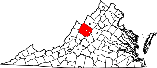
English: This is a locator map showing Augusta County in Virginia. For more information, see Commons:United States county locator maps. |
| Siku | |
| Ukaboni |
Chinthu chane: English: The maps use data from nationalatlas.gov, specifically countyp020.tar.gz on the Raw Data Download page. The maps also use state outline data from statesp020.tar.gz. The Florida maps use hydrogm020.tar.gz to display Lake Okeechobee. |
| Mlembi | David Benbennick |
| SVG genesis |
Chilolezo
| I, the copyright holder of this work, release this work into the public domain. This applies worldwide. In some countries this may not be legally possible; if so: I grant anyone the right to use this work for any purpose, without any conditions, unless such conditions are required by law. |
Mbili ya chinthu
Dofyani pa siku/nyengo kuti muone umo vikaonekela pa nyengo iyo.
| Siku/Nyengo | Kachithuzi | Vipimo | Mgwiliski | Ganizo | |
|---|---|---|---|---|---|
| sono | 17:38, 12 Febuluwale 2006 | | 7,486 × 3,247 (223 KB) | David Benbennick | {{subst:User:Dbenbenn/clm|county=Augusta County|state=Virginia|type=county}} |
Magwiliskilo ntchito
The following page uses this file:
Umo chinthu chagwiliskikila ntchito
Ma wiki ghanyake agho ghakugwiliska ichi:
- Magwiliskilo pa ar.wikipedia.org
- Magwiliskilo pa bg.wikipedia.org
- Magwiliskilo pa bpy.wikipedia.org
- Magwiliskilo pa cdo.wikipedia.org
- Magwiliskilo pa ceb.wikipedia.org
- Magwiliskilo pa ce.wikipedia.org
- Magwiliskilo pa cs.wikipedia.org
- Magwiliskilo pa cy.wikipedia.org
- Magwiliskilo pa de.wikipedia.org
- Magwiliskilo pa en.wikipedia.org
- List of cities and counties in Virginia
- Augusta County, Virginia
- Craigsville, Virginia
- Crimora, Virginia
- Dooms, Virginia
- Fishersville, Virginia
- Greenville, Virginia
- Jolivue, Virginia
- Lyndhurst, Virginia
- Sherando, Virginia
- Stuarts Draft, Virginia
- Verona, Virginia
- Weyers Cave, Virginia
- Grottoes, Virginia
- Battle of Piedmont
- Ladd, Virginia
- Ferrol, Virginia
- South River (South Fork Shenandoah River tributary)
- Swoope, Virginia
- Augusta Springs, Virginia
- Fort Defiance, Virginia
- Churchville, Virginia
- Mount Solon, Virginia
- Buffalo Gap, Virginia
- Moscow, Virginia
- Natural Chimneys
- Centerville, Augusta County, Virginia
- Spring Hill, Virginia
- Cowbane Prairie Natural Area Preserve
Wonani magwiliskilo ghanandi ghapa charu gha chinthu ichi.