
File:Map of California highlighting Tuolumne County.svg

Size of this PNG preview of this SVG file: 523 × 599 pixels. Mu misani inyake: 209 × 240 pixels | 419 × 480 pixels | 670 × 768 pixels | 894 × 1,024 pixels | 1,787 × 2,048 pixels | 1,022 × 1,171 pixels.
Chinthu cha kwenekuko (SVG file, nominally 1,022 × 1,171 pixels, file size: 508 KB)
Mwakudumula
| Malongosolelo |
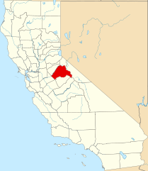
English: This is a locator map showing Tuolumne County in California. For more information, see Commons:United States county locator maps. |
| Siku | |
| Ukaboni |
Chinthu chane: English: The maps use data from nationalatlas.gov, specifically countyp020.tar.gz on the Raw Data Download page. The maps also use state outline data from statesp020.tar.gz. The Florida maps use hydrogm020.tar.gz to display Lake Okeechobee. |
| Mlembi | David Benbennick |
Chilolezo
| I, the copyright holder of this work, release this work into the public domain. This applies worldwide. In some countries this may not be legally possible; if so: I grant anyone the right to use this work for any purpose, without any conditions, unless such conditions are required by law. |
Mbili ya chinthu
Dofyani pa siku/nyengo kuti muone umo vikaonekela pa nyengo iyo.
| Siku/Nyengo | Kachithuzi | Vipimo | Mgwiliski | Ganizo | |
|---|---|---|---|---|---|
| sono | 16:03, 26 Novembala 2016 | | 1,022 × 1,171 (508 KB) | Spartan7W | Update HQ map |
| 10:28, 12 Febuluwale 2006 |  | 9,164 × 10,536 (229 KB) | David Benbennick | {{subst:User:Dbenbenn/clm|county=Tuolumne County|state=California}} |
Magwiliskilo ntchito
The following page uses this file:
Umo chinthu chagwiliskikila ntchito
Ma wiki ghanyake agho ghakugwiliska ichi:
- Magwiliskilo pa ar.wikipedia.org
- Magwiliskilo pa az.wikipedia.org
- Magwiliskilo pa ban.wikipedia.org
- Magwiliskilo pa bg.wikipedia.org
- Magwiliskilo pa bpy.wikipedia.org
- Magwiliskilo pa ca.wikipedia.org
- Magwiliskilo pa ceb.wikipedia.org
- Magwiliskilo pa ce.wikipedia.org
- Magwiliskilo pa cs.wikipedia.org
- Magwiliskilo pa cy.wikipedia.org
- Magwiliskilo pa da.wikipedia.org
- Magwiliskilo pa de.wikipedia.org
- Magwiliskilo pa en.wikipedia.org
- List of counties in California
- Tuolumne County, California
- Chinese Camp, California
- Columbia, California
- East Sonora, California
- Groveland-Big Oak Flat, California
- Jamestown, California
- Mi-Wuk Village, California
- Mono Vista, California
- Phoenix Lake-Cedar Ridge, California
- Sonora, California
- Soulsbyville, California
- Tuolumne City, California
- Twain Harte, California
- Template:Tuolumne County, California
Wonani magwiliskilo ghanandi ghapa charu gha chinthu ichi.