
File:Kenya counties map Labelled.jpg
Saizi ya chakuona ichi: 421 × 599 pixels. Mu misani inyake: 169 × 240 pixels | 337 × 480 pixels | 540 × 768 pixels | 1,136 × 1,616 pixels.
Chinthu cha kwenekuko (1,136 × 1,616 pixels, file size: 182 KB, MIME type: image/jpeg)
Mwakudumula
| Malongosolelo |
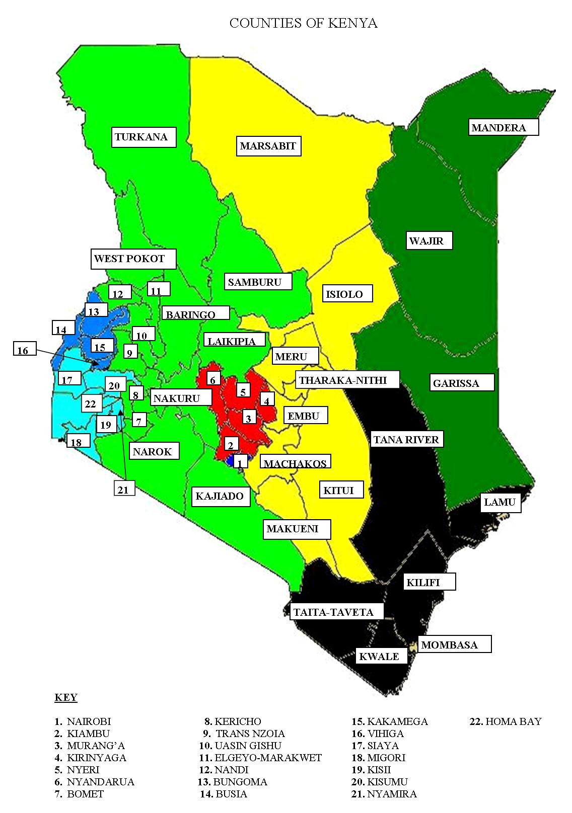
English: A map of the counties of Kenya as envisioned in the Constitution of 2010. Provinces shown by colors. I hope the labeling is accurate :) |
| Siku | |
| Ukaboni | Chinthu chane |
| Mlembi | Kimemia Maina |
| Other versions |
|


Chilolezo
I, the copyright holder of this work, hereby publish it under the following license:
Chinthu ichi ntchakuzomelezgeka na Creative Commons Attribution-Share Alike 3.0 Unported license.
- Ndimwe ŵakuzomelezgeka:
- kugaŵa – kuti mutandazge, kugaŵa na kusintha ntchito
- kusazga – kusintha chito iyi
- Pa malango ghakulondezga agha:
- Viyambilo vya kuchita – Mukwenela kupeleka malumbo ghawemi, kupeleka linki yakutyonda ku chilolezo, kweneso yowoyaniso pala vinyake vyasintha. Mukwenela kuchita nthena mwakwenelela, kwambula kujikhalila khonde.
- mwa kugaŵana – Pala mwasazga panji mwasintha chinthu, mukwenela kuchitandazga
Mbili ya chinthu
Dofyani pa siku/nyengo kuti muone umo vikaonekela pa nyengo iyo.
| Siku/Nyengo | Kachithuzi | Vipimo | Mgwiliski | Ganizo | |
|---|---|---|---|---|---|
| sono | 13:16, 28 Juni 2011 | | 1,136 × 1,616 (182 KB) | AnonMoos | losslessly cropping |
| 10:39, 28 Juni 2011 |  | 1,240 × 1,754 (206 KB) | Kimemia Maina |
Magwiliskilo ntchito
The following page uses this file:
Umo chinthu chagwiliskikila ntchito
Ma wiki ghanyake agho ghakugwiliska ichi:
- Magwiliskilo pa en.wikipedia.org
- Magwiliskilo pa ja.wikipedia.org
- Magwiliskilo pa ko.wikipedia.org
- Magwiliskilo pa lt.wikipedia.org
- Magwiliskilo pa nso.wikipedia.org
- Magwiliskilo pa vec.wikipedia.org