
File:CongoLualaba watershed plain political.png

Saizi ya chakuona ichi: 721 × 599 pixels. Mu misani inyake: 289 × 240 pixels | 578 × 480 pixels | 924 × 768 pixels | 1,150 × 956 pixels.
Chinthu cha kwenekuko (1,150 × 956 pixels, file size: 213 KB, MIME type: image/png)
Mwakudumula
| Malongosolelo |
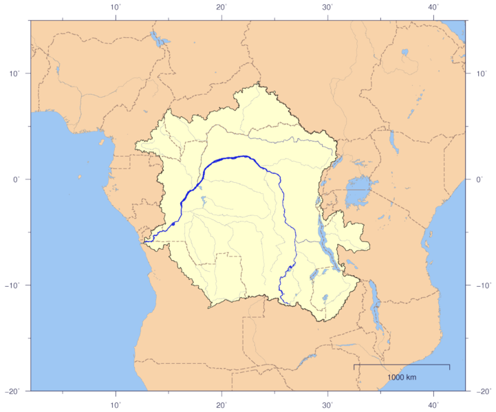
English: Course and Watershed of the Congo and Lualaba River with political boundaries.
Deutsch: Verlauf und Einzugsgebiet von Kongo und Lualaba mit Staatsgrenzen. |
| Siku | |
| Ukaboni | The map has been created with the Generic Mapping Tools: http://gmt.soest.hawaii.edu/ using additional public comain data from the VMAP0 data set. |
| Mlembi | Imagico |
| Chilolezo (Kugwiliskaso ntchito ichi) |
This file is licensed under the Creative Commons Attribution-Share Alike 2.5 Generic license.
|
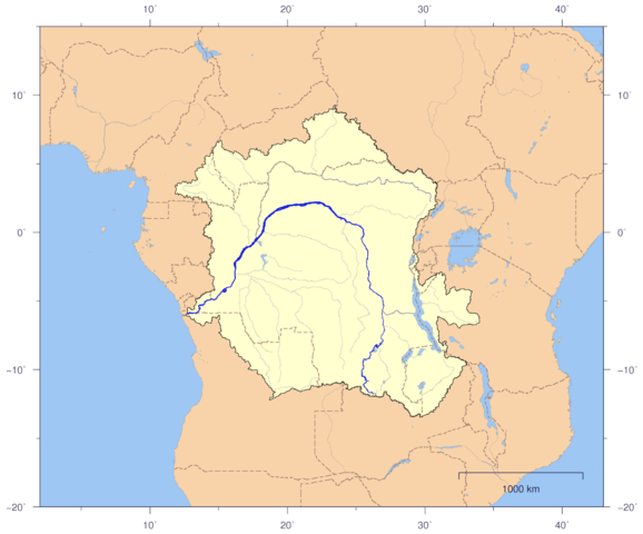
| Other versions | Image:CongoLualaba_watershed_plain.png |
Chilolezo
I, the copyright holder of this work, hereby publish it under the following license:
This file is licensed under the Creative Commons Attribution-Share Alike 2.5 Generic license.
- Ndimwe ŵakuzomelezgeka:
- kugaŵa – kuti mutandazge, kugaŵa na kusintha ntchito
- kusazga – kusintha chito iyi
- Pa malango ghakulondezga agha:
- Viyambilo vya kuchita – Mukwenela kupeleka malumbo ghawemi, kupeleka linki yakutyonda ku chilolezo, kweneso yowoyaniso pala vinyake vyasintha. Mukwenela kuchita nthena mwakwenelela, kwambula kujikhalila khonde.
- mwa kugaŵana – Pala mwasazga panji mwasintha chinthu, mukwenela kuchitandazga
Mbili ya chinthu
Dofyani pa siku/nyengo kuti muone umo vikaonekela pa nyengo iyo.
| Siku/Nyengo | Kachithuzi | Vipimo | Mgwiliski | Ganizo | |
|---|---|---|---|---|---|
| sono | 21:02, 3 Janyuwale 2007 | | 1,150 × 956 (213 KB) | Imagico | {{Information |Description= {{en|Course and Watershed of the Congo and Lualaba River with political boundaries.}} {{de|Verlauf und Einzugsgebiet von Kongo und Lualaba mit Staatsgrenzen.}} |Source=The map has been created with the [[:en:Generic Mapping Too |
Magwiliskilo ntchito
Palije majani agho ghogwiliska chinthu ichi.
Umo chinthu chagwiliskikila ntchito
Ma wiki ghanyake agho ghakugwiliska ichi:
- Magwiliskilo pa af.wikipedia.org
- Magwiliskilo pa ar.wikipedia.org
- Magwiliskilo pa as.wikipedia.org
- Magwiliskilo pa bcl.wikipedia.org
- Magwiliskilo pa bn.wikipedia.org
- Magwiliskilo pa ca.wikipedia.org
- Magwiliskilo pa el.wikipedia.org
- Magwiliskilo pa en.wikipedia.org
- Magwiliskilo pa es.wikipedia.org
- Magwiliskilo pa fa.wikipedia.org
- Magwiliskilo pa fr.wikipedia.org
- Magwiliskilo pa ha.wikipedia.org
- Magwiliskilo pa hy.wikipedia.org
- Magwiliskilo pa it.wikipedia.org
- Magwiliskilo pa ja.wikipedia.org
- Magwiliskilo pa jv.wikipedia.org
- Magwiliskilo pa kg.wikipedia.org
- Magwiliskilo pa kk.wikipedia.org
- Magwiliskilo pa ky.wikipedia.org
- Magwiliskilo pa la.wikipedia.org
- Magwiliskilo pa ml.wikipedia.org
- Magwiliskilo pa mr.wikipedia.org
- Magwiliskilo pa no.wikipedia.org
- Magwiliskilo pa pt.wikipedia.org
- Magwiliskilo pa rw.wikipedia.org
- Magwiliskilo pa sv.wikipedia.org
- Magwiliskilo pa ta.wikipedia.org
- Magwiliskilo pa te.wikipedia.org
- Magwiliskilo pa tr.wiktionary.org
- Magwiliskilo pa uz.wikipedia.org
- Magwiliskilo pa vec.wikipedia.org
- Magwiliskilo pa vi.wikipedia.org
- Magwiliskilo pa za.wikipedia.org