
File:POLSKA mapa woj z powiatami.png
Saizi ya chakuona ichi: 646 × 600 pixels. Mu misani inyake: 259 × 240 pixels | 517 × 480 pixels | 1,021 × 948 pixels.
Chinthu cha kwenekuko (1,021 × 948 pixels, file size: 467 KB, MIME type: image/png)

|
This locator map image could be re-created using vector graphics as an SVG file. This has several advantages; see Commons:Media for cleanup for more information. If an SVG form of this image is available, please upload it and afterwards replace this template with
{{vector version available|new image name}}.
It is recommended to name the SVG file “POLSKA mapa woj z powiatami.svg”—then the template Vector version available (or Vva) does not need the new image name parameter. |
Mwakudumula
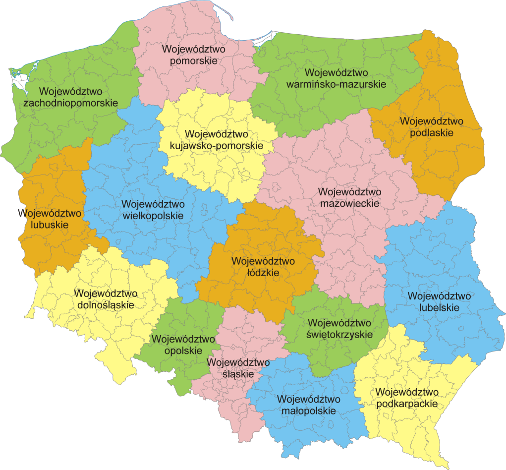
Mapa administracyjna Polski z zaznaczonymi granicami województw i powiatów, stan na 1 stycznia 2007. Autor: aç
Administrative map of Poland with borders of województwa (voivodships) and powiaty (counties), as of January 1, 2007. By Aotearoa
Chilolezo
I, the copyright holder of this work, hereby publish it under the following licenses:

|
Chilolezo ntchakupelekeka pakupanga copy, kutandazga panj kusintha na malango gha GNU Free Documentation License, Version 1.2 or any later version published by the Free Software Foundation; with no Invariant Sections, no Front-Cover Texts, and no Back-Cover Texts. A copy of the license is included in the section entitled GNU Free Documentation License. |
| Chinthu ichi ntchakuzomelezgeka na Creative Commons Attribution-Share Alike 3.0 Unported license. | ||
na dango la same or compatible license nga ntchiphya. | ||
| This licensing tag was added to this file as part of the GFDL licensing update. |
This file is licensed under the Creative Commons Attribution 2.5 Generic license.
- Ndimwe ŵakuzomelezgeka:
- kugaŵa – kuti mutandazge, kugaŵa na kusintha ntchito
- kusazga – kusintha chito iyi
- Pa malango ghakulondezga agha:
- Viyambilo vya kuchita – Mukwenela kupeleka malumbo ghawemi, kupeleka linki yakutyonda ku chilolezo, kweneso yowoyaniso pala vinyake vyasintha. Mukwenela kuchita nthena mwakwenelela, kwambula kujikhalila khonde.
You may select the license of your choice.
Mbili ya chinthu
Dofyani pa siku/nyengo kuti muone umo vikaonekela pa nyengo iyo.
| Siku/Nyengo | Kachithuzi | Vipimo | Mgwiliski | Ganizo | |
|---|---|---|---|---|---|
| sono | 20:37, 5 Febuluwale 2007 | | 1,021 × 948 (467 KB) | Aotearoa | Mapa administracyjna Polski z zaznaczonymi granicami województw i powiatów, stan na 1 stycznia 2007. Autor: Aotearoa<br> Administrative map of Poland with borders of województwa (voivodships) and powiaty (counties), as of January 1, 2 |
Magwiliskilo ntchito
The following page uses this file:
Umo chinthu chagwiliskikila ntchito
Ma wiki ghanyake agho ghakugwiliska ichi:
- Magwiliskilo pa azb.wikipedia.org
- Magwiliskilo pa bs.wikipedia.org
- Magwiliskilo pa ca.wikipedia.org
- Magwiliskilo pa da.wikipedia.org
- Magwiliskilo pa de.wikipedia.org
- Magwiliskilo pa de.wikivoyage.org
- Magwiliskilo pa el.wikipedia.org
- Magwiliskilo pa en.wikipedia.org
- Magwiliskilo pa es.wikivoyage.org
- Magwiliskilo pa fa.wikipedia.org
- Magwiliskilo pa fr.wikipedia.org
- Magwiliskilo pa he.wikipedia.org
- Magwiliskilo pa hr.wikipedia.org
- Magwiliskilo pa hu.wikipedia.org
- Magwiliskilo pa hy.wikipedia.org
- Magwiliskilo pa id.wikipedia.org
- Magwiliskilo pa incubator.wikimedia.org
- Magwiliskilo pa is.wikipedia.org
- Magwiliskilo pa it.wikipedia.org
- Magwiliskilo pa lb.wikipedia.org
- Magwiliskilo pa ln.wikipedia.org
- Magwiliskilo pa mg.wikipedia.org
- Magwiliskilo pa ms.wikipedia.org
- Magwiliskilo pa mzn.wikipedia.org
- Magwiliskilo pa nn.wikipedia.org
- Magwiliskilo pa no.wikipedia.org
- Magwiliskilo pa pam.wikipedia.org
- Magwiliskilo pa pcd.wikipedia.org
- Magwiliskilo pa pl.wikipedia.org
Wonani magwiliskilo ghanandi ghapa charu gha chinthu ichi.